Draw a sketch map of Africa, on it marks and labels the regions experiencing tropical continental vegetation. (4mks)Africa is a diverse continent with a wide range of vegetation types. One of the prominent vegetation regions found in Africa is the tropical continental vegetation. This type of vegetation is characterized by lush, dense forests and abundant biodiversity. In this sketch map of Africa, we will mark and label the regions experiencing tropical continental vegetation, showcasing the areas where this unique ecosystem thrives. Locations of the regions experiencing tropical continental vegetation.
 The sketch map of Africa highlights the regions experiencing tropical continental vegetation. These areas, such as the Congo Basin, West Africa, East Africa, and Madagascar, are characterized by dense forests, abundant rainfall, and rich biodiversity. Understanding and preserving these regions is crucial for the conservation of unique plant and animal species and maintaining the ecological balance of the continent.
0 Comments
Factors Contributing to the Decline of Natural Grasslands in KenyaThe decline of natural grasslands in Kenya is a concerning issue that has significant implications for the environment and wildlife. Several factors have contributed to this decline, leading to the loss of valuable grassland ecosystems. Understanding these factors is crucial for implementing effective conservation strategies. This essay will discuss four key factors that have led to the decline of natural grasslands in Kenya. Explain four factors that has led to the decline of natural grasslands in Kenya. (6mks)
The decline of natural grasslands in Kenya is a complex issue influenced by multiple factors.
Overgrazing, agricultural expansion, urbanization, infrastructure development, and climate change have all played a role in the degradation and loss of grassland ecosystems. To address this decline, it is essential to implement sustainable land management practices, promote responsible grazing, and protect remaining grassland areas. Conservation efforts should focus on restoring degraded grasslands, raising awareness about the importance of grassland ecosystems, and integrating climate change adaptation strategies. By addressing these factors, we can work towards preserving and restoring the valuable natural grasslands of Kenya for future generations. Factors Contributing to the Decline of Natural Grasslands in KenyaThe natural grasslands of Kenya have experienced a significant decline in recent years. This decline can be attributed to various factors that have had a detrimental impact on the grassland ecosystems. Understanding these factors is crucial for implementing effective conservation measures. In this essay, we will explore four key factors that have led to the decline of natural grasslands in Kenya. Explain four factors that has led to the decline of natural grasslands in Kenya. (6mks)
The decline of natural grasslands in Kenya is a result of multiple factors, including overgrazing, agricultural expansion, climate change, and the invasion of non-native plant species. To address this decline, it is essential to implement sustainable land management practices, promote responsible grazing, and raise awareness about the importance of conserving grassland ecosystems. Additionally, efforts should be made to control and manage invasive species to restore the integrity of natural grasslands. By addressing these factors and implementing conservation measures, we can work towards preserving and restoring the valuable grassland ecosystems in Kenya.
The Significance of Vegetation in Human ActivitiesVegetation plays a crucial role in supporting various human activities and has significant impacts on both the physical environment and human well-being. From providing essential resources to contributing to environmental sustainability, the importance of vegetation cannot be overstated. This article will outline five key significance of vegetation to human activities. Outline five significance of vegetation to human activities. (5mks)
Vegetation is not only essential for the survival of ecosystems but also plays a vital role in supporting human activities. From environmental protection to economic benefits and aesthetic value, the significance of vegetation cannot be overlooked. It is crucial to recognize the importance of preserving and sustainably managing vegetation for the well-being of both humans and the planet.
Understanding Soil Profile: Layers and Significance for Plant GrowthSoil profile plays a crucial role in determining the characteristics and properties of soil, which in turn influence plant growth and distribution. Understanding the layers and composition of the soil profile is essential for optimizing agricultural practices and ensuring optimal plant growth. In this article, we will explore the significance of soil profile and its impact on plant growth, considering factors such as pH, drainage, depth, moisture content, temperature, aeration, mineral composition, and soil classification. The term "soil profile" refers to the vertical arrangement of different layers or horizons of soil from the surface down to the bedrock. It is a description of the various layers that make up the soil, each with its own distinct characteristics and properties. The soil profile provides valuable information about the composition, structure, and fertility of the soil, as well as its ability to support plant growth. By studying the soil profile, we can gain insights into the processes of soil formation and the factors that influence soil properties. In conclusion, the soil profile, with its vertical arrangement of layers, provides valuable insights into the composition, structure, and fertility of the soil.
The characteristics and properties of the soil profile, such as pH, drainage, depth, moisture content, temperature, aeration, mineral composition, and soil classification, have a significant impact on plant growth and distribution. By understanding and analyzing the soil profile, farmers and researchers can make informed decisions regarding soil management practices, crop selection, and nutrient supplementation, leading to improved agricultural productivity and sustainable farming practices. It is essential to recognize the importance of soil profile in order to harness the full potential of our land resources and ensure the success of agricultural endeavors. Draw a well labeled diagram showing soil catenaA soil catena refers to the arrangement of soil on a mountain slope from top to bottom. It illustrates the sequence of soils that occur down a slope, showcasing how soils can change without significant variations in climate or parent rock. 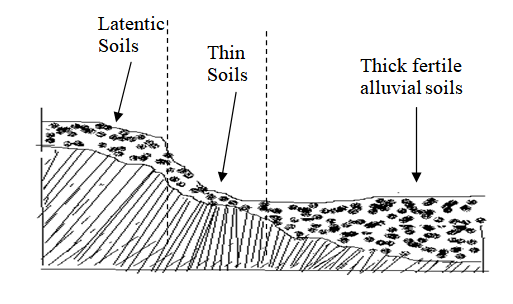 SOIL CATENA Factors that influence the development of a soil catena include relief, drainage, and transportation of debris.
In summary, a soil catena is a sequence of soils found on a mountain slope, showcasing the changes in soil characteristics from top to bottom. Factors such as relief, drainage, and transportation of debris influence the development of different soil types within the catena. Explain how the following factors influence the formation of soils.Parent RockThe characteristics of the parent rock have a significant influence on the composition and structure of the soil. Let's break it down:
 Living organismsLiving organisms play a crucial role in the breakdown of rocks and the chemical composition of soil. Here's a breakdown of their contributions:
TopographyTopography plays a significant role in influencing weathering and soil characteristics. Here's a breakdown of its impact:
Characteristics and Agricultural Suitability of Chernozen SoilsChernozen soils, also known as Chernozems, have distinct characteristics that make them unique. Here are the key characteristics of chernozen soils:
The effects of soil erosion can be quite significant and detrimental to the environment. Here are some of the major effects of soil erosion:
El Niño: A Fascinating Weather Phenomenon and Its Intricate Causes
El Niño: A Fascinating Weather Phenomenon and Its Intricate Causes Introduction El Niño, a climatic phenomenon that originates in the tropical Pacific Ocean, has captivated scientists and weather enthusiasts for decades. It is characterized by abnormal warming of the ocean surface, leading to widespread changes in weather patterns across the globe. The name "El Niño" translates to "the little boy" or "Christ child" in Spanish, reflecting its tendency to occur around Christmas time. In this essay, we will delve deeper into the causes of El Niño and unravel the intricate mechanisms behind this intriguing phenomenon. Causes of El Niño El Niño is primarily driven by the complex interactions between the ocean and the atmosphere in the tropical Pacific region. One of the key factors contributing to the onset of El Niño is the weakening or reversal of the trade winds. These winds blow from east to west across the equatorial Pacific, pushing warm surface waters towards the western Pacific. As a result, cooler water upwells along the coast of South America, creating a nutrient-rich environment that supports thriving marine ecosystems. During an El Niño event, however, the trade winds weaken or even reverse their direction. This leads to a redistribution of warm surface waters towards the central and eastern Pacific, causing a rise in ocean temperatures. The altered wind patterns disrupt the normal flow of warm water, which has a cascading effect on the global climate system. Another crucial component in the development of El Niño is the weakening of the upwelling process along the coast of South America. Upwelling refers to the upward movement of cold, nutrient-rich waters from the deep ocean to the surface. This process is vital for supporting the abundant marine life in the region. However, during an El Niño event, the weakened trade winds reduce the upwelling, resulting in warmer surface waters and a decline in the productivity of marine ecosystems. The Role of the Southern Oscillation The Southern Oscillation, a large-scale atmospheric circulation pattern, is closely intertwined with El Niño. It involves the shifting of atmospheric pressure between the eastern and western Pacific. When the pressure is higher in the eastern Pacific (known as El Niño Southern Oscillation or ENSO), it is associated with El Niño conditions. Conversely, when the pressure is higher in the western Pacific (known as La Niña), it signifies cooler ocean temperatures and enhanced upwelling. The Southern Oscillation Index (SOI), which measures the difference in air pressure between Tahiti and Darwin, Australia, is commonly used to monitor the state of the Pacific climate system. A positive SOI indicates La Niña conditions, while a negative SOI signifies El Niño conditions. By analyzing the fluctuations in the SOI, scientists can gain valuable insights into the occurrence and intensity of El Niño events. Impacts of El Niño El Niño exerts a profound influence on weather patterns across the globe, causing significant disruptions in climate systems. Its impacts are wide-ranging and vary depending on geographical location. In some regions, El Niño leads to increased rainfall and flooding, while in others, it triggers droughts and heatwaves. For instance, during an El Niño event, the western coast of South America experiences heavy rainfall, often resulting in devastating floods. Conversely, Southeast Asia and Australia tend to be drier than usual, experiencing prolonged droughts that can have severe implications for agriculture and water resources. El Niño can also influence the formation and intensity of tropical cyclones. In the Atlantic Ocean, it can suppress hurricane activity, leading to a quieter hurricane season. However, in the Pacific Ocean, it can enhance the development of tropical cyclones, potentially increasing the risk of destructive storms. Conclusion El Niño is a captivating weather phenomenon that continues to intrigue scientists and researchers worldwide. The interplay between the ocean and the atmosphere, driven by factors such as trade winds, upwelling, and the Southern Oscillation, sets the stage for the occurrence of El Niño events. Understanding the causes and consequences of El Niño is crucial for predicting and managing its impacts on society, agriculture, and ecosystems. By studying this complex phenomenon, we can enhance our ability to adapt and mitigate the challenges posed by El Niño and its far-reaching effects on global weather patterns. The diagram below shows features resulting from glacial deposition on a lowland area  Name the features marked X, Y and Z.
With the aid of a well-labelled diagram, describe the formation of cyclonic rainfall. (6 marks)
 The diagram below shows a weather measuring instrument. Use it to answer the questions below9/7/2023
The diagram below shows a weather measuring instrument. Use it to answer the questions below
i) Name the parts marked A and D. (2 marks)

A - Spherical glass lens D - Sensitized card ii) Describe how the instrument works.sensitized card which is graduated in hours and minutes. The heat burns the paper/card as the sun moves across the sky. The unburnt sections in the card indicates when there was cloud cover. At the end of the day, the card is removed and the number of hours that the sun shone are obtained by adding the burnt sections on the card. (c) The table below shows climatic figure for station Q. Use it to answer the questions that follow.
(i) Calculate the annual range of temperature for station Q. (2 marks)

(ii) Outline four characteristics of climate in station Q. (4 marks)
How compressional forces can lead to the formation of a rift valley 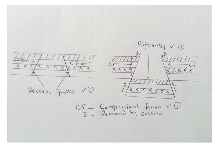 Explanation;
The diagram below shows a soil profile. Use it to answer question (i) and (ii).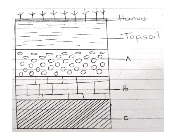 (i) Name the parts marked A, B and C. (3 marks)
(ii) Describe the characteristics of the top soil (4 marks)
​Study the map of Nyeri (East Africa 1:50,000) to answer questions that follow(a) (i) what is the sheet number of the map extract. (1 mark) ü 120/ (ii) Give the longitudinal extent of the area covered by the map extract. (1 mark) ü From 36°45’E to 37°00’E
(b) (i) Give two reasons which show that the area receives high rainfall. (2 marks) ü Presence of forests ü Coffee production ü Presence of many permanent rivers/streams (Any 2x1mk =2mks) (ii Nametwo physical features found in the grid square 6246 (2 marks) ü River valley ü Steep slope ü spurs (c) Draw a rectangle 4 cm by 6 cm to represent the area north of Northing 60 and between Eastings 64 and 68. On it mark and label o River Amboni(Honi) o Road B5 o Mweiga township (5 marks) 
(d) Describe the drainage of the area covered by the map (4 marks)ü There are many permanent rivers ü The main drainage pattern is dendritic ü There are water holes ü There are many dams ü The main rivers are Amboni, Muringato,Chanya ü Most rivers are flowing from west to east (Any 4x1mk = 4mks)
(e) Students of Njogu-ini school wanted to do a field study on vegetation on the area covered by the map.(i) Identify two means of transport they are likely to use. ( 2 marks)ü Roads ü water (ii) Name three types of vegetation they are likely to identify (3 marks)ü Bamboo ü Scrub ü Thicket ü Forest ü Woodland (Any 3x1mk = 3mks) (iii) State three preparations they could make. (3 marks)ü conduct pre-visit/ reconnaissance ü Draw a route map ü Prepare working schedule ü Seek permission from school management ü Gather all the necessary tools (iv) Identify two problems they are likely to encounter. (2 marks)ü Difficult to access some areas due to thick vegetation (2mks) ü They might be scared/attacked by dangerous wild animals in the thickets ü Heavy downpour which might have interrupted the field study ü Fatigue ü Accidents from falls ü Uncooperative respondents ü Unable to identify some vegetation (Any 2x1mk = 2mks) The diagram below shows a coastal landform  (a) Name the features marked P and K. (2 Mks)
(b) List down three types of ocean tides. (3 Mks)
The diagram below shows the hydrological cycle. 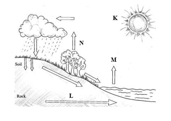 What processes do the arrows labelled K, L and N represent
You intend to carry out a field study of a weather station in your school.
Give two methods of recording data that you are likely to use.
State three reasons why the recording of data at a school weather station may be inaccurate.9/7/2023 State three reasons why the recording of data at a school weather station may be inaccurate.
Three types of faults
Explain four positive effects of glaciations in lowland areas.
Describe how terminal moraine is formed.
State four ways of conserving soils
Describe plucking as a process of glacial erosion.
|

Archives
March 2024
Categories
All
|
 RSS Feed
|
Primary Resources
College Resources
|
Secondary Resources
|
Contact Us
Manyam Franchise
P.O Box 1189 - 40200 Kisii Tel: 0728 450 424 Tel: 0738 619 279 E-mail - sales@manyamfranchise.com |