|
The diagram below shows features resulting from glacial deposition on a lowland area  Name the features marked X, Y and Z.
0 Comments
With the aid of a well-labelled diagram, describe the formation of cyclonic rainfall. (6 marks)
 The diagram below shows a weather measuring instrument. Use it to answer the questions below9/7/2023
The diagram below shows a weather measuring instrument. Use it to answer the questions below
i) Name the parts marked A and D. (2 marks)

A - Spherical glass lens D - Sensitized card ii) Describe how the instrument works.sensitized card which is graduated in hours and minutes. The heat burns the paper/card as the sun moves across the sky. The unburnt sections in the card indicates when there was cloud cover. At the end of the day, the card is removed and the number of hours that the sun shone are obtained by adding the burnt sections on the card. (c) The table below shows climatic figure for station Q. Use it to answer the questions that follow.
(i) Calculate the annual range of temperature for station Q. (2 marks)

(ii) Outline four characteristics of climate in station Q. (4 marks)
How compressional forces can lead to the formation of a rift valley 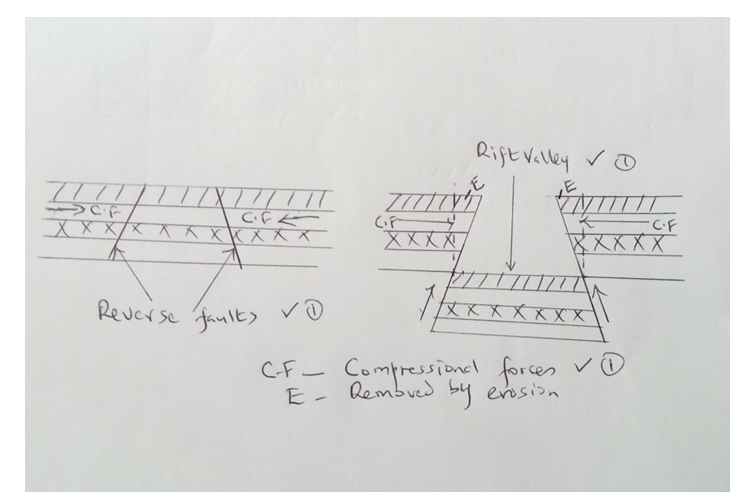 Explanation;
The diagram below shows a soil profile. Use it to answer question (i) and (ii).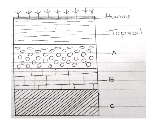 (i) Name the parts marked A, B and C. (3 marks)
(ii) Describe the characteristics of the top soil (4 marks)
​Study the map of Nyeri (East Africa 1:50,000) to answer questions that follow(a) (i) what is the sheet number of the map extract. (1 mark) ü 120/ (ii) Give the longitudinal extent of the area covered by the map extract. (1 mark) ü From 36°45’E to 37°00’E
(b) (i) Give two reasons which show that the area receives high rainfall. (2 marks) ü Presence of forests ü Coffee production ü Presence of many permanent rivers/streams (Any 2x1mk =2mks) (ii Nametwo physical features found in the grid square 6246 (2 marks) ü River valley ü Steep slope ü spurs (c) Draw a rectangle 4 cm by 6 cm to represent the area north of Northing 60 and between Eastings 64 and 68. On it mark and label o River Amboni(Honi) o Road B5 o Mweiga township (5 marks) 
(d) Describe the drainage of the area covered by the map (4 marks)ü There are many permanent rivers ü The main drainage pattern is dendritic ü There are water holes ü There are many dams ü The main rivers are Amboni, Muringato,Chanya ü Most rivers are flowing from west to east (Any 4x1mk = 4mks)
(e) Students of Njogu-ini school wanted to do a field study on vegetation on the area covered by the map.(i) Identify two means of transport they are likely to use. ( 2 marks)ü Roads ü water (ii) Name three types of vegetation they are likely to identify (3 marks)ü Bamboo ü Scrub ü Thicket ü Forest ü Woodland (Any 3x1mk = 3mks) (iii) State three preparations they could make. (3 marks)ü conduct pre-visit/ reconnaissance ü Draw a route map ü Prepare working schedule ü Seek permission from school management ü Gather all the necessary tools (iv) Identify two problems they are likely to encounter. (2 marks)ü Difficult to access some areas due to thick vegetation (2mks) ü They might be scared/attacked by dangerous wild animals in the thickets ü Heavy downpour which might have interrupted the field study ü Fatigue ü Accidents from falls ü Uncooperative respondents ü Unable to identify some vegetation (Any 2x1mk = 2mks) The diagram below shows a coastal landform  (a) Name the features marked P and K. (2 Mks)
(b) List down three types of ocean tides. (3 Mks)
The diagram below shows the hydrological cycle. 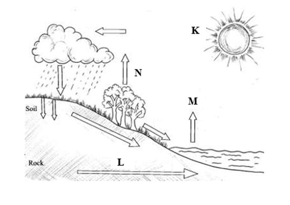 What processes do the arrows labelled K, L and N represent
You intend to carry out a field study of a weather station in your school.
Give two methods of recording data that you are likely to use.
State three reasons why the recording of data at a school weather station may be inaccurate.9/7/2023 State three reasons why the recording of data at a school weather station may be inaccurate.
Three types of faults
Explain four positive effects of glaciations in lowland areas.
Describe how terminal moraine is formed.
State four ways of conserving soils
Describe plucking as a process of glacial erosion.
Explain three conditions that lead to glacial deposition.
Define soil
Explain how the following factors influence soil formation Parent material
Human activities
Explain three causes of physical soil degeneration
Explain three ways in which features resulting from faulting are of economic importance:
A part from the Rift Valley name two other relief features that were formed as result of faulting.9/7/2023 A part from the Rift Valley name two other relief features that were formed as result of faulting.
Describe two ways in which faulting may influence drainage systems.
Name two instruments kept in a Stevenson screen.
Describe the origin of continents according to the theory of continental drift.
|

Archives
March 2024
Categories
All
|
 RSS Feed