|
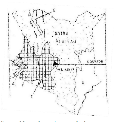
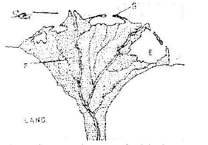
SECTION A Answer all questions in this section. 1. a) Explain the origin of the earth and the solar system according to the Nebula cloud theory. (4mks) b) Name two other theories that explain the origin of the earth and the solar system apart from the Nebula cloud theory. (2mks) 2. a) List two zones of transition in the atmosphere. (2mks) b) Give three evidences that the interior of the earth is hotter. (3mks) 3. a) Define the following terms. i) River divide (1mk) ii) A confluence (1mk) iii) A river profile (1mk) b) List three factors that influence the formation of a river. (3mks) 4. How is an oasis formed? (4mks) 5. List four characteristics of Mediterranean climate. (4mks) SECTION B: Answer questions six and any other two questions. 6. (a) Study the map of Kijabe 1: 50,000 sheet 134/3 provided and answer the following questions (i) Give the approximate height of peak of Kijabe hill. (1mk) (ii) Measure the length of the Naivasha –Nairobi railway line from landhies (Grid ref 257987) to the level crossing near Kijabe station (grid reference 308984). Give your answer in kilometers and Meters.) (2mks) (iii) Name the relief feature on the map that may have created problems during the construction of the railway line. (1mk) (b) Describe the drainage of the area covered by the map extract. (5mks) (c) Explain how relief has influenced the distribution of settlement in the area covered by the map extract. (4mks) (d) Citing evidence from the map, state four economic activities carried out in the area covered by the map extract. ( 4 mks) (e) Suppose you were to carry out a field study at Wakangwe forest: (i) Design a working schedule that you would use during the day of the study. (5mks) (ii) Give reasons why it would be necessary to sample part of the forest for the study. (2mks) (iii) State two ways in which your findings would be useful to the local community. (2mks) 7. a) i) What is faulting? (1mk) ii) With the use of a well labeled diagram explain how a reverse fault occurs. (5mks) iii) State two other types of faults apart from reverse faults. (2mks) b) Describe how a rift valley forms through tensional forces. (4mks) c) Explain three ways in which features resulting from faulting are of economic importance to man. (6mks) d) You intend to carry out a field study of the landforms around your school. i) State two hypotheses you are likely to formulate for the study. (2mks) ii) Apart from dividing your class into groups, in what three other ways will you prepare for the study. (3mks) ii) In what two ways is dividing the class into groups important? (2mks) 8. a) i) Differentiate between intrazonal and azonal soils. (2mks) ii) Give three examples of a zonal soils (3mks) b) i) Explain four factors that influence soil formation. (8mks) ii) Give two factors that determine the colour of soil (2mks) c) i) What is soil erosion. (2mks) ii) Explain four ways in which vegetation prevents soil erosion. (8mks) 9 a) i) Name a country in Africa where temperate grassland is found. (1mk) ii) State four characteristics of temperate grasslands. (4mks) b) i) Explain four ways trees in the coniferous forests have adapted to the environmental conditions of the region. (8mks) c) You are required to carry a field study on a forest near your school. Describe the methods you would use to determine each of the following aspects of the trees in the forest. i) Age of the trees. (3mks) ii) Height of the trees. (3mks) iii) Tree species (3mks) 10. The figure below shows underground zones of saturation. Use it to answer question a (i) 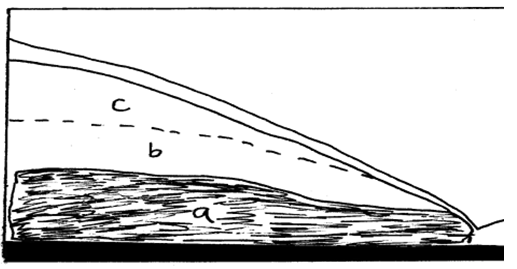 a) i) Identify the zones marked a, b, and c. (3mks) ii) Name four sources of groundwater. (4mks) b) Explain four ways in which groundwater is of significance to human activities. (8mks) c) i) Give two examples of lakes in East Africa that have formed due to crustal warping. (2mks) ii) Describe how the process of crustal warping leads to formation of lakes. (5mks) iii) State three other processes that lead to formation of lakes apart from crustal warping. MARKING SCHEMESECTION A 1. a) Origin of the solar system and the earth according to the Nebular Cloud Theory - There existed a big cloud ✓ (Nebular of hot gases and dust) - This cloud which was rotating at a very high speed ✓ flattened into a disk due to centrifugal force.✓ - Very hot materials concentrated at the centre✓ of the rotating cloud and led to the formation of the sun - Some masses of gases and dust were thrown off as ✓ the cloud continued to rotate - The particles consolidated, cooled and contracted to form planets✓ 1 x 4 = 4mks b) Other theories - The twin star theory/ big bang✓ - The passing star theory✓ - Biblical/ creation theory✓ 1 x 2 = 2mks 2. a) Transitional zones of the atmosphere - Tropopouse - Stratopause✓ - Mesopause✓ 1 x 2 = 2mks b) Evidences that the interior of the earth is hotter - During volcanic eruptions hot material (magma) are ejected onto the surface✓ - Occurrence of hot springs on the ground✓ - Progressive increasing heat experienced as mines and borings get deeper✓ - The molten state of rocks in the mantle✓ 1 x 3 = 3mks 3. a) Defining (i) River divide – It is a ridge line/ hill ground that separates two or more river basins✓ (ii) A confluence – The point at which a tributary joins the main river✓ (iii) A river profile – This is the longitudinal cross section of a river from the source to the mouth.✓ 1 x 3 = 3mks b) Factors that influence the formation of a river - Vegetation cover✓ - Climate✓ - Nature of rocks✓ - The degree of slope✓ - Land use systems e.g. irrigation✓ 1 x 3 = 3mks 4. How an oasis forms - A pre-existing depression is deepened by eddy action/ deflation✓ - Gradually the depression is excavated through wind abrasions✓ - The surface is lowered until it reaches the water bearing rock/ aquifer / table - Water oozes out of the ground and collects in the depression to form an oasis✓ 1 x 4 = 4mks 5. Characteristics of mediterranean climate - Summers are hot with temperatures of about 210C✓ - Winters are mild/ cold with temperatures of about 110C✓ - Mean annual rainfall moderate varies between 500 – 900 mm with most of it falling in winter✓ - The region mainly experiences cyclonic rainfall✓ - Trade winds are offshore in summer and onshore westerlies dominate in winter✓ - Hot and cold local winds are common✓ 1 x 4 = 4mks Total = 25 marks SECTION B 6. (a) Study the map of Kijabe 1: 50,000 sheet 134/3 provided and answer the following questions (i) Give the approximate height of peak of Kijabe hill. (1mk) ● 2260m- less than 2280m. (ii) Measure the length of the Naivasha –Nairobi railway line from landhies (Grid ref 257987) to the level crossing near Kijabe station (grid reference 308984). Give your answer in kilometers and Meters.) (2mks) ● 5 kilometres 600metres. (5.6km is wrong for the requirement of the question.) (iii) Name the relief feature on the map that may have created problems during the construction of the railway line. (1mk) ● Hill (b) Describe the drainage of the area covered by the map extract. (5mks) ● The main drainage feature are rivers. ● The main river is R.Ewaso Kedong. ● The area has disappearing rivers. ● The area has radial drainage pattern. ● Most rivers display dendritic drainage pattern ● The area has a water trough. ● The area has water holes. (5*1mk) (Student scores without giving the reference on the map-the question has not asked “giving evidence from the map”) (c) Explain how relief has influenced the distribution of settlement in the area covered by the map extract. (4mks) ● Steep slopes have few settlements to the north west/around Kijabe hill. ● Gentler slopes have attracted higher settlements e.g. around Magina.(Any 2*2mks) (d) Citing evidence from the map, state four economic activities carried out in the area covered by the map extract. ( 4 mks) ● Trade-Presence of shops ● Livestock rearing-Presence of cattle dips/dairy(This is one marking point) ● Tourism-Presence of hot springs. ● Transport-Presence of roads. ● Lumbering-Presence of a sawmill. ● Manufacturing-Presence of carbacid plant. ● Quarrying-Presence of a quarry. (e) Suppose you were to carry out a field study at Wakangwe forest: (i) Design a working schedule that you would use during the day of the study. (5mks) 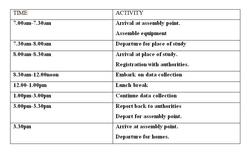 (ii) Give reasons why it would be necessary to sample part of the forest for the study. (2mks) ● To save time by reducing the area to be covered. ● To reduce fatigue for the participants by reducing area to be covered by individuals. ● To ensure thorough scrutiny of the sampled area. (iii) State two ways in which your findings would be useful to the local community. (2mks) ● Will form basis for future research. ● Will reveal the importance of forests to the general community hence forest conservation. 7. a) (i) What is faulting - It is the fracturing/ cracking of crustal rocks ✓1 (ii) Formation of reverse fault - Formed when crustal rocks are exposed to compressional forces✓ - A reverse fault develops ✓ - Continued pushing of compressional forces lead tone block being pushed over the other to form a reverse fault ✓ 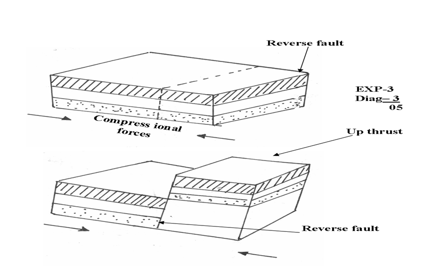 (iii) Other types of faults
- Normal faults✓ - Shear/ tear/ slip/ strike slip/ wrench/ trancurrent✓ - Thrust fault/ over throw✓ - Anticlinal faults✓ 1 x 2 = 2mks b) How a rift valley forms through tensional forces - Layers of rocks in a region are subjected to tensional forces✓ - Lines of weakness develop, resulting in the development of normal faults✓ - As the forces pull the side blocks away, the middle block sinks✓ - The block that has sunk forms the floor of the rift valley ✓ 1 x 4 = 4mks c) Economic importance of features formed through faulting - Block/ horst mountains are a source of rivers which provide water for HEP production e.t.c✓✓ - Rift valley formation has led to the exposure of minerals e.g. diatomite which are mined on the rift valley floor✓✓ - Rift valley lakes formed through faulting are important fishing grounds ✓✓ - Faulted features provide scenery which promote tourist industry✓✓ - Block mountains attract rainfall which favour agriculture/ settlement✓✓ 2 x 3 = 6mks d) (i) Hypotheses - Most landforms near my school have resulted from faulting✓ - Presence of block mountains around my school has influenced tourism✓ - Mountains are the dominant landforms around my school✓ Any relevant points 1 x 2 = 2mks (ii) Other ways of preparing for the study - Seeking permission from relevant authorities✓ - Conducting a pre-visit/ reconnaissance✓ - Preparing a questionnaire✓ - Holding discussions in class✓ - Preparing a working schedule✓ - Reading through relevant books✓ - Gathering the required tools✓ 1 x 3 = 3mks (iii) Importance of dividing into groups - It eases congestion/ overcrowding in areas they have to visit✓ - It helps in ensuring that required data is collected within the time frame given✓ - It creates order when carrying out the field study✓ - Ensures that everybody is involved in the study✓ 1 x 2 = 2mks Total = 25 marks 8. a) (i) Difference between intrazonal and azonal soils - Intrazonal soils are those soils that are formed under poor drainage conditions e.g. water logged areas whereas azonal soils are those soils that have not had adequate time to develop. They are thus immature soils.✓✓ The difference must come out clearly to score (ii) Examples of azonal soils - Mountain/ scree soils✓ - Alluvial soils✓ - Glacial soils✓ - Loess✓ - Volcanic soils recently formed✓ b) (i) Factors that influence soil formation - Parent rock✓F Nature of the rock influences the rate of weathering ✓EX hard rocks weather slowly while soft rocks weather fast The rock determines the soil texture e.g. large grained rocks produce large grained soils - Living organisms✓F They assist in the breaking down of rocks through burrowing ✓EX The roots of bigger plants break up the soil as they grow and allow water to pass through - Topography✓ It determines the rate of weathering e.g. steep slopes encourages high rate of weathering✓EX It influences soil depth e.g. gentle slopes have deep soils while steep slopes have thin soils It influences soil drainage e.g. where land is flat soils are poorly drained - Climate✓F Affects the rate and type of weathering that takes place ✓EX Determines the rate of leaching Elements of climate i.e. Temperature accelerates weathering leading to soil formation - Time✓F For soil to reach maturity, time is required✓EX F = max 04 EX = max 04 Total = 8mks (ii) Type of parent material✓ Chemical composition of the soil✓ Drainage of the area✓ c) (i) What is soil erosion The process by which the top soil is removed/ detached and carried away ✓✓ by various agents at a rate that is faster than it is being replaced by the soil forming processes (ii) Way vegetation prevents soil erosion - The leaf cover helps to reduce the force of raindrops which would otherwise loosen and remove soil particles if the force is not checked✓✓ - The rate of infiltration of rainwater into the soil is increased by vegetation cover thus reducing surface run off ✓✓ - Plant cover breaks the force of wind at the ground level and reduces the transportation of soil particles/ reduces the evaporation which would dry and loosen the soil✓ - Decayed vegetation matter provides humus which binds the soil particles together✓ 2 x 5 = 10mks Total = 25 marks 9. a) (i) A country in Africa where temperate grassland is found - South Africa✓1 (ii) 4 characteristics of temperate grasslands - Treeless except along water courses ✓ - Grass is short and tough in the drier areas✓ - Grass is tall in the moist areas✓ - Grass withers in Autumn and dies in Winter✓ - Grass sprout in springs✓ - Grass is nutritious✓ 1 x 4 = 4mks b) (i) Ways in which trees in the coniferous forests have adapted to the environmental conditions - The trees have a conical shape and flexible branches to allow snow to slide off easily thus minimizing damage to the trees✓✓ - Most trees are evergreen so as to have maximum utilization of sunlight during the short drowing season ✓✓ - Needle like leaves help to reduce the loss of water from the trees in winter when there is no moisture to be absorbed from the soil✓✓ - The tree trunks are flexible to enable them sway without breaking during the strong winter winds.✓✓ - The leaves have a tough waxy skin which protects them from the winter cold✓✓ - The trees have a widely spread root system for utilizing moisture from the top soil since most of the time the subsoil is frozen✓✓ 2 x 4 = 8mks (ii) Factors that determine zoning of mountain vegetation - Altitude✓ - Aspect✓ - Slope✓ - Temperature✓ - Moisture availability✓ 1 x 3 = 3mks c) (i) Methods likely to be used in determining: I. Age of trees - Asking the local people / forest officer / when the trees may have been planted✓ - Observing the rings on the tree stump and counting them to find out the age of the trees✓ - By estimating the age of trees - Refering to available records to know when the trees were planted 1 x 3 = 3mks II. Height of trees - By estimating the height ✓ - By measuring the exact height of samples of trees and generalising✓ - Calculate using the ratio of height of near short object in relation to height of its, relate to the shadow of the tree in relation to its height. 1 x 3 = 3mks III. Tree species - By walking through the forest observing and noting the various species ✓ - By interviewing the local people / forester✓ - By reading through available records✓ 1 x 3 = 3mks Total = 25 marks 10. a) (i) The zones marked a – zone of permanent saturation/ phreatic zone✓ b – zone of intermittent saturation✓ c – zone of non – saturation ✓ 1 x 3 = 3mks (ii) Sources of ground water - Rain water✓ - Lake/ sea water✓ - Melt water✓ - Magmatic/ plutonic water✓ 1 x 4 = 4mks b) Significance of ground water - Sources of rivers – Many springs are sources of river that provide water for industrial / domestic use ✓✓ - Ground water is used for irrigating the land all over the world thus promotes agriculture✓✓ - Ground water influences the development of settlements✓✓ - Hotsprings are a tourist attraction✓✓ - At the mouths of many hotsprings, valuable mineral salts are deposited and people exploit them for economic gain✓✓ 2 x 4 = 8mks c) (i) Lakes that have formed due to crustal warping in East Africa - Lake Victoria✓ - Lake Kyoga✓ - Lake Wamala✓ - Lake Kachira✓ 1 x 2 = 2mks (ii) How crustal warping leads to the formation of lakes - Earth movements cause crustal downwarping ✓ - This leads to the formation of a basin like depression✓ - Uplifting of landmasses around the depression diverted the flow of rivers into the depression causing reversed drainage✓ - Deposition onto the depression resulted in to further downwarping✓ - Water from the rivers accumulated in the depression to form a lake✓ 1 x 5 = 5mks (iii) Other processes that lead to formation of lakes - Faulting✓ - Vulcanicity✓ - Erosion✓ - Deposition✓ - Meteorite falling✓ - Human activities✓ 1 x 3 = 3mks Total = 25 marks
0 Comments
KCSE Geography Paper 1 2001 Section B Question 9. (a) Name three components of soil.
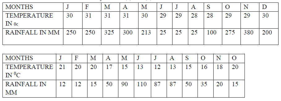
(b) Explain how the following factors influence the formation of soil |

Archives
March 2024
Categories
All
|


 RSS Feed