|
0 Comments
Name two forces responsible for the geoid shape of the earthName two forces responsible for the geoid shape of the earth. (2mks)
The geoid shape of the Earth is determined by two forces: centripetal force and centrifugal force. Let me explain further:
Give three reasons why the interior of the earth is very hot. (3mks)
The interior of the Earth is very hot due to several reasons. Here are three reasons why:
River capture, also known as stream piracy or stream capture, refers to the natural diversion of the headwaters of one river into the channel of another river with greater erosional activity. It is an important geomorphic process that can reshape landscapes and alter river systems. To understand the conditions necessary for river capture to occur, we can refer to the information provided in the documents. State three conditions necessary for river capture to take place. (3mks)
In conclusion, river capture is a natural process that occurs when the headwaters of one river are diverted into the channel of another river with greater erosional activity. Three necessary conditions for river capture to take place include a difference in river levels, adjacent valleys and watersheds, and the presence of a wider valley and more active headward erosion in the pirate river. Understanding these conditions helps us comprehend the complex dynamics of river systems and their evolution over time.
River Capture: Features, Conditions, and Examples of this Natural PhenomenonDefine the term river capture (2mks) The diversion of the headwaters of a less powerful river into a more powerful river in an adjacent valley. River capture, also known as stream piracy or stream capture, refers to the natural phenomenon where the headwaters of a less powerful river are diverted into the channel of a more powerful river in an adjacent valley.
This process occurs when the tributaries of the more powerful river erode their source through headward erosion and capture the headwaters of the adjoining system. The captured river, also known as the misfit or underfit stream, loses its original headwaters and its flow is redirected into the channel of the capturing river. During river capture, several features and conditions can be observed:
In western Kenya, the Sondu River was captured by the Miriu River from the Asaw River, leaving a wind gap at the present Sondu market. River capture can also be observed in Europe, such as the capture of the upper Doubs from the Rhine and the capture of the former upper Meuse by the Moselle near Toul. In summary, river capture is the process by which the headwaters of a less powerful river are diverted into a more powerful river in an adjacent valley. It is characterized by features such as elbows of capture, drygaps, and river rejuvenation. Several conditions must be met for river capture to occur, including adjacent valleys, differential erosion, and active headward erosion. Human Activities and Climate Change: Understanding the Causes and ImpactsHuman activities have a significant impact on the Earth's climate, contributing to climate change and its far-reaching implications on the environment. Through the release of greenhouse gases, deforestation, industrialization, and energy consumption, humans have altered the delicate balance of the Earth's climate system. Understanding these activities and their consequences is crucial for developing sustainable solutions to mitigate the effects of climate change. Outline four human activities that contribute to climatic change. (4mks)
In conclusion, the four major human activities that contribute to climate change - greenhouse gas emissions, deforestation, industrialization, and energy consumption - have profound implications on the environment. These activities have led to rising global temperatures, melting ice caps, rising sea levels, changes in rainfall patterns, and increased frequency of extreme weather events.
The consequences of climate change are far-reaching, affecting ecosystems, agriculture, water resources, and human health. It is imperative that we take collective action to reduce greenhouse gas emissions, promote reforestation, adopt cleaner energy sources, and implement sustainable practices to mitigate the impacts of climate change and ensure a sustainable future for generations to come. The Four Orogenies in Geological History and their Fold MountainsWelcome to this comprehensive exploration of the four orogenies known in geological history and their corresponding fold mountains. In this content, we will delve into the time periods, specific examples, and significance of folding in creating these remarkable geological features. Join us as we uncover the fascinating world of orogenies and fold mountains. Name the four orogenies that are known in the geological history. (4mks)
In conclusion, the four orogenies known in geological history have played a significant role in shaping the Earth's landscape. From the ancient Charnian Orogeny to the more recent Alpine Orogeny, each period has left behind a legacy of fold mountains that continue to captivate and inspire. Understanding the formation and significance of these fold mountains provides valuable insights into the dynamic processes that have shaped our planet over millions of years. So, let us continue to explore and appreciate the wonders of geology and the remarkable stories written in the folds of these majestic mountains.
Formation of Fold Mountains: Unveiling the Role of Plate TectonicsFold mountains are majestic landforms that have captivated geologists and explorers for centuries. Understanding the process of their formation is crucial in unraveling the dynamic forces shaping our planet. According to the plate tectonics theory, fold mountains are primarily formed through the collision of tectonic plates. This article explores the key stages of fold mountain formation, providing a well-labeled diagram to illustrate the process. With aid of a well labeled diagram describe how fold mountains are formed according to the plate tectonics theory (7mks)
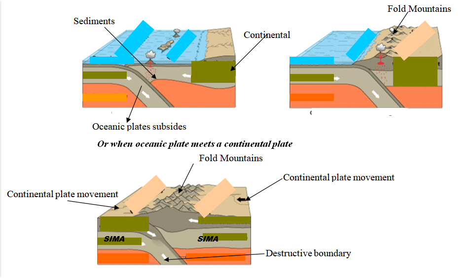 The plate tectonics theory provides a comprehensive explanation for the formation of fold mountains. Through the collision of tectonic plates, compression, folding, and uplift, these magnificent landforms emerge. The process is a testament to the immense forces at work beneath the Earth's surface. Understanding the formation of fold mountains not only enriches our knowledge of geological processes but also helps us appreciate the profound influence of tectonic activity on shaping our planet's landscapes.
The Influence of Fold Mountains on Climate: Exploring Four Key FactorsFold mountains are majestic geological formations that have a significant influence on climate patterns in the regions where they are found. These towering mountain ranges not only shape the landscape but also play a crucial role in determining local weather conditions. In this discussion, we will explore four key ways in which fold mountains influence climate, including solar radiation, wind patterns, rainfall distribution, and temperature variations. Explain four ways in which fold mountains influence climate (8mks)
Fold mountains have a profound influence on climate due to their topographic features and geographical positioning. The slopes of these mountains receive direct sunshine, leading to variations in solar radiation and temperature. The topography also affects wind patterns, creating local winds that can impact weather conditions. Additionally, the orographic effect causes variations in rainfall distribution, with windward slopes receiving more precipitation. Understanding the ways in which fold mountains influence climate is crucial for studying and predicting weather patterns in mountainous regions.
Unveiling the Forces of Wind Erosion in Deserts: Three Key Processes1.(a) Describe three ways in which wind erosion occurs in deserts. (6mks)
(b) With the aid of a well labeled diagram, describe the formation of the following features (i) Yardangs (6mks)
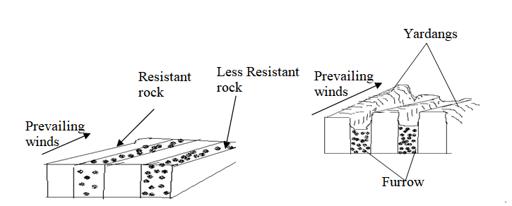 NB: TEXT = 4MKS, DIAGRAM 2 MKS NB: Diagram scores only if the direction of the prevailing winds and the arrangement of rocks are correct. (ii) Mushroom blocks. (6mks)
NB: Diagram scores only if the direction of the prevailing winds and the arrangement of rocks are correct. 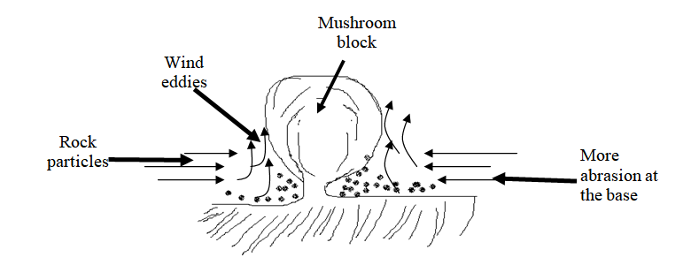 YOU INTEND TO CARRY OUT A FIELD STUDY ON DESERT LANDFORMS, STATE TWO OBJECTIVES OF YOUR STUDY.30/12/2023 You intend to carry out a field study on desert landforms, State two objectives of your study.(c)You intend to carry out a field study on desert landforms. a.State two objectives of your study. (2mks)
b.List three features formed through water action you are likely to identify (3mks)
c.Give two problems you are likely to encounter during the field study. (2mks)
The Significance of Vegetation: Exploring Distribution, Characteristics, and UsesDefine the term vegetation zone. (2mks) This is an expansive area having plant cover that gives it a distinct character. Vegetation zone refers to an extensive area that is characterized by a specific type of plant cover. It is a region where plants, including trees, shrubs, herbs, and grasses, grow together and create a distinct environment.
Vegetation zones are defined by the types of plants that dominate the area and are influenced by factors such as climate, soil conditions, and topography. These zones can vary in size and can be found at different scales, ranging from local ecosystems to global biomes. The vegetation within a zone plays a crucial role in shaping the physical and biological characteristics of the area, as well as providing habitat for various organisms. Understanding vegetation zones is essential for studying ecosystems, biodiversity, and the interactions between plants and their environment. Draw a sketch map of Africa, on it marks and labels the regions experiencing tropical continental vegetation. (4mks)Africa is a diverse continent with a wide range of vegetation types. One of the prominent vegetation regions found in Africa is the tropical continental vegetation. This type of vegetation is characterized by lush, dense forests and abundant biodiversity. In this sketch map of Africa, we will mark and label the regions experiencing tropical continental vegetation, showcasing the areas where this unique ecosystem thrives. Locations of the regions experiencing tropical continental vegetation.
 The sketch map of Africa highlights the regions experiencing tropical continental vegetation. These areas, such as the Congo Basin, West Africa, East Africa, and Madagascar, are characterized by dense forests, abundant rainfall, and rich biodiversity. Understanding and preserving these regions is crucial for the conservation of unique plant and animal species and maintaining the ecological balance of the continent.
Factors Contributing to the Decline of Natural Grasslands in KenyaThe decline of natural grasslands in Kenya is a concerning issue that has significant implications for the environment and wildlife. Several factors have contributed to this decline, leading to the loss of valuable grassland ecosystems. Understanding these factors is crucial for implementing effective conservation strategies. This essay will discuss four key factors that have led to the decline of natural grasslands in Kenya. Explain four factors that has led to the decline of natural grasslands in Kenya. (6mks)
The decline of natural grasslands in Kenya is a complex issue influenced by multiple factors.
Overgrazing, agricultural expansion, urbanization, infrastructure development, and climate change have all played a role in the degradation and loss of grassland ecosystems. To address this decline, it is essential to implement sustainable land management practices, promote responsible grazing, and protect remaining grassland areas. Conservation efforts should focus on restoring degraded grasslands, raising awareness about the importance of grassland ecosystems, and integrating climate change adaptation strategies. By addressing these factors, we can work towards preserving and restoring the valuable natural grasslands of Kenya for future generations. Factors Contributing to the Decline of Natural Grasslands in KenyaThe natural grasslands of Kenya have experienced a significant decline in recent years. This decline can be attributed to various factors that have had a detrimental impact on the grassland ecosystems. Understanding these factors is crucial for implementing effective conservation measures. In this essay, we will explore four key factors that have led to the decline of natural grasslands in Kenya. Explain four factors that has led to the decline of natural grasslands in Kenya. (6mks)
The decline of natural grasslands in Kenya is a result of multiple factors, including overgrazing, agricultural expansion, climate change, and the invasion of non-native plant species. To address this decline, it is essential to implement sustainable land management practices, promote responsible grazing, and raise awareness about the importance of conserving grassland ecosystems. Additionally, efforts should be made to control and manage invasive species to restore the integrity of natural grasslands. By addressing these factors and implementing conservation measures, we can work towards preserving and restoring the valuable grassland ecosystems in Kenya.
The Significance of Vegetation in Human ActivitiesVegetation plays a crucial role in supporting various human activities and has significant impacts on both the physical environment and human well-being. From providing essential resources to contributing to environmental sustainability, the importance of vegetation cannot be overstated. This article will outline five key significance of vegetation to human activities. Outline five significance of vegetation to human activities. (5mks)
Vegetation is not only essential for the survival of ecosystems but also plays a vital role in supporting human activities. From environmental protection to economic benefits and aesthetic value, the significance of vegetation cannot be overlooked. It is crucial to recognize the importance of preserving and sustainably managing vegetation for the well-being of both humans and the planet.
Understanding Soil Profile: Layers and Significance for Plant GrowthSoil profile plays a crucial role in determining the characteristics and properties of soil, which in turn influence plant growth and distribution. Understanding the layers and composition of the soil profile is essential for optimizing agricultural practices and ensuring optimal plant growth. In this article, we will explore the significance of soil profile and its impact on plant growth, considering factors such as pH, drainage, depth, moisture content, temperature, aeration, mineral composition, and soil classification. The term "soil profile" refers to the vertical arrangement of different layers or horizons of soil from the surface down to the bedrock. It is a description of the various layers that make up the soil, each with its own distinct characteristics and properties. The soil profile provides valuable information about the composition, structure, and fertility of the soil, as well as its ability to support plant growth. By studying the soil profile, we can gain insights into the processes of soil formation and the factors that influence soil properties. In conclusion, the soil profile, with its vertical arrangement of layers, provides valuable insights into the composition, structure, and fertility of the soil.
The characteristics and properties of the soil profile, such as pH, drainage, depth, moisture content, temperature, aeration, mineral composition, and soil classification, have a significant impact on plant growth and distribution. By understanding and analyzing the soil profile, farmers and researchers can make informed decisions regarding soil management practices, crop selection, and nutrient supplementation, leading to improved agricultural productivity and sustainable farming practices. It is essential to recognize the importance of soil profile in order to harness the full potential of our land resources and ensure the success of agricultural endeavors. Draw a well labeled diagram showing soil catenaA soil catena refers to the arrangement of soil on a mountain slope from top to bottom. It illustrates the sequence of soils that occur down a slope, showcasing how soils can change without significant variations in climate or parent rock. 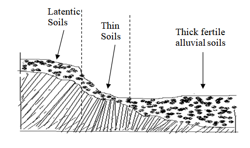 SOIL CATENA Factors that influence the development of a soil catena include relief, drainage, and transportation of debris.
In summary, a soil catena is a sequence of soils found on a mountain slope, showcasing the changes in soil characteristics from top to bottom. Factors such as relief, drainage, and transportation of debris influence the development of different soil types within the catena. Explain how the following factors influence the formation of soils.Parent RockThe characteristics of the parent rock have a significant influence on the composition and structure of the soil. Let's break it down:
 Living organismsLiving organisms play a crucial role in the breakdown of rocks and the chemical composition of soil. Here's a breakdown of their contributions:
TopographyTopography plays a significant role in influencing weathering and soil characteristics. Here's a breakdown of its impact:
Characteristics and Agricultural Suitability of Chernozen SoilsChernozen soils, also known as Chernozems, have distinct characteristics that make them unique. Here are the key characteristics of chernozen soils:
The effects of soil erosion can be quite significant and detrimental to the environment. Here are some of the major effects of soil erosion:
|

Archives
March 2024
Categories
All
|


 RSS Feed