KCSE Geography Paper 2 1999 Section B Question 9 with Answers.(a) The map below shows some major tea growing areas in Kenya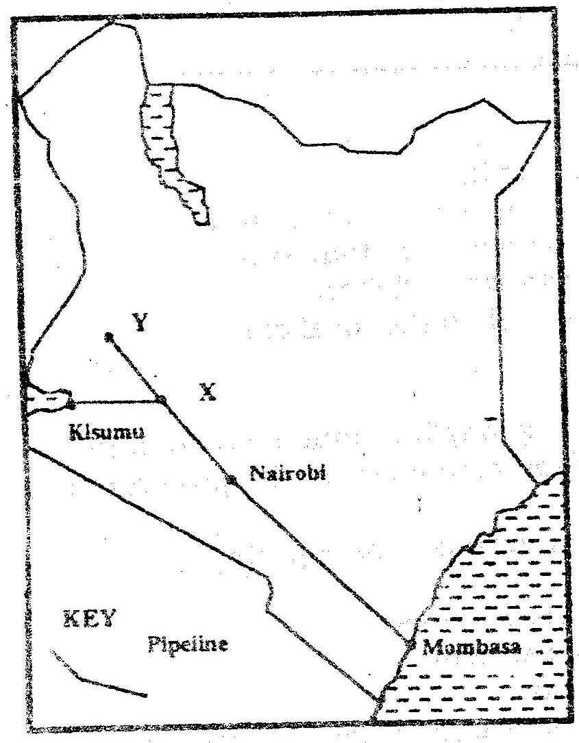
(i) Name the areas marked W, X, and Y
0 Comments
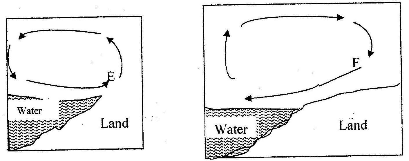
KCSE Geography Paper 2 1999 Section B Question 8 with Answers.The map below shows some major fishing grounds in the world. Use it to answer question (a)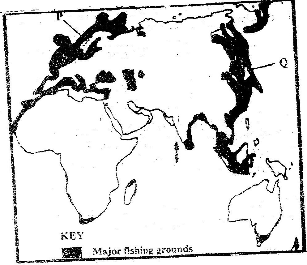
(a) (i) Name the countries marked P and Q (2mks)
(ii) Explain four conditions that favour fishing in the shaded coastal waters (8mks)KCSE Geography Paper 2 1999 Section B Question 7 with Answers.The pyramid below represents the population structure of country X. Use it to answer question (a)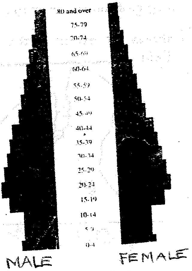
(a) Describe the characteristic of the population represented by the pyramid (5mks)KCSE Geography Paper 2 1999 Section B Question 6 with Answers.The table below shows total number of livestock in Kenya in 1986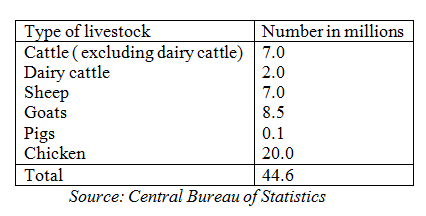
(a) Using a radius of 5cm, draw a pie chart to represent the information given in the table aboveKCSE Geography Paper 2 1999 Section A Question 5 with Answers.(a) Apart from desertification, name two other environmental hazards experienced in Kenya
(b) State two causes of desertificationKCSE Geography Paper 2 1999 Section A Question 4 with Answers.(a) Give three advantages of railway over road transport
(b) The map below shows the extent of the oil pipeline in Kenya. Use it to answer question (b) (i)
The map below shows the extent of the oil pipeline in Kenya. Use it to answer question (b) (i)
KCSE Geography Paper 2 1999 Section A Question 3 with Answers.(a) (i) Apart from providing power state three other benefits of the dams along river Tana
(ii) State two problems that affect hydroelectric power production along river TanaKCSE Geography Paper 2 1999 Section A Question 2 with Answers.State three problems facing commercial poultry farming in Kenya
KCSE Geography Paper 2 1999 Section A Question 1 with Answers.Give four reasons why wildlife conservation is encouraged in Kenya
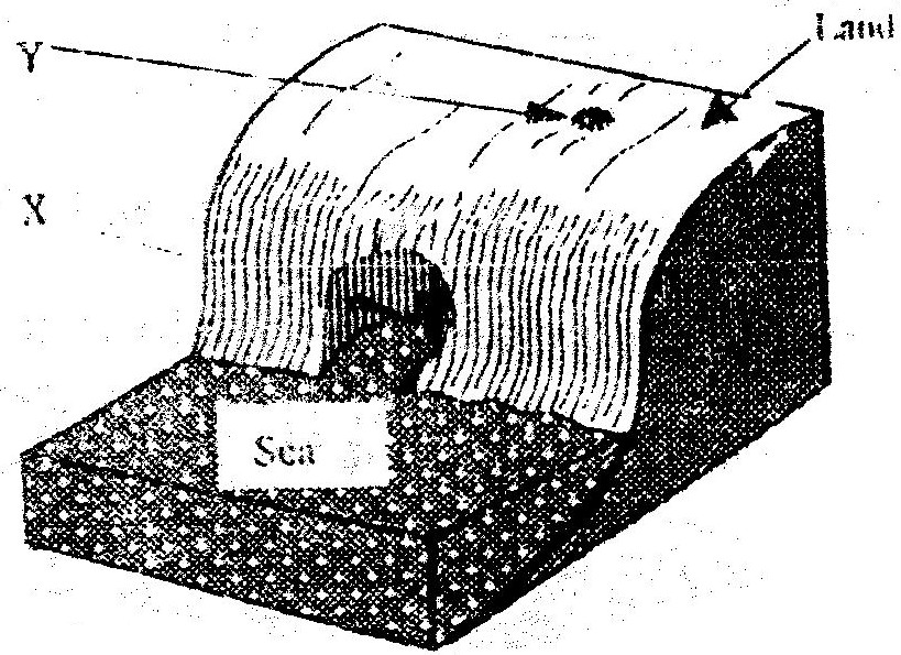
Tourism and Wildlife Form 4 LevelKCSE Geography Paper 1 1999 Section B Question 9 with Answers.The diagram below represents zones of natural vegetation on a mountain use it to answer questions (a)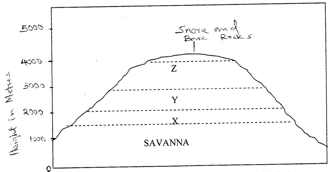
(i) In your answer booklet, name the zones marked X,Y and Z
(ii) Describe the characteristics of a tropical Savannah vegetation
(iii) State two reasons why the mountaintop has no vegetation
(b) Explain three factors that have led to a decline of the natural grassland in Kenya.
(c) Suppose you were to carry out a field study on the relationship between vegetation and altitude(i) State three objectives you would formulate for your study
(ii) State three methods you would use to record the information collected during the field study
(iii) Name two types of maps you would draw to present your findings.
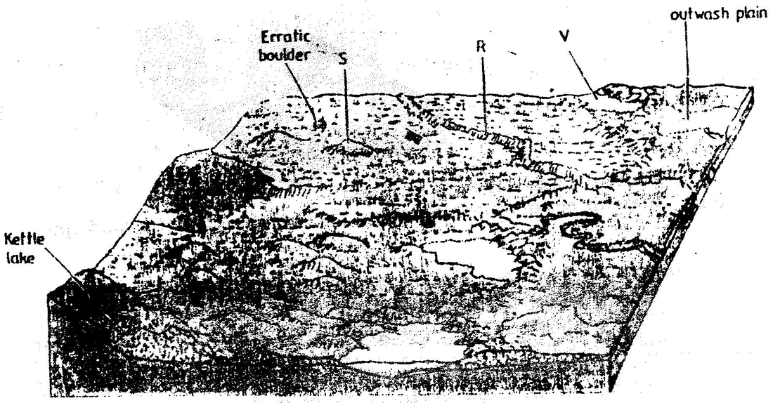
Vegetation, Fields Study, Form 2KCSE Geography Paper 1 1999 Section B Question 8 with Answers.(a) describe how a river erodes its channels by the following process.
|
|
|

Archives
March 2024
January 2024
December 2023
November 2023
July 2023
June 2023
August 2022
May 2022
October 2021
March 2021
February 2021
January 2021
December 2019
August 2019
Categories
All
Action-of-water-in-limestone-areas
Action-of-wind-and-water-in-arid-areas
Agriculture
Air Mass
Aridity And Desertification
Boran
CASH CROPS
Catchment Area
Climate
Cocoa
Communication
Continental Drift
CRUST
CYCLONIC RAINFALL
DATELINE
Definition Of Geography Terms
DRAINAGE
Earth Movement
Earthquakes
EAST AFRICA
Eco-Tourism
ECO- TOURISM
El Nino
Energy
ENVIRONMENTAL HAZARDS
EQUINOX
Farming
Faulting
Field Work
Fishing
FLOODS
Folding
Forestry
FORESTS
Form 1
Form 2
Form 3
FORM 4
Ghana
Glaciation
GRAPHS
HARDWOODS
HUMIDITY
Hydrological Cycle
INDIA
Indigenous Beef Cattle
Industrialization
Industry
Internal Land Forming Processes
Introduction To Geography
IRRIGATION
ITCZ
Ivory Coast
JAPAN
Kcse-1996
Kcse-1997
Kcse-1998
Kcse-1999
Kcse-2000
Kcse-2000
KCSE 2001
KCSE 2002
Kcse-2003
Kcse-2004
Kcse-2005
Kcse-2006
Kcse-2007
Kcse-2008
Kcse-2009
Kcse-2010
Kcse-2011
Kcse-2012
Kcse-2013
Kcse-2014
Kcse-2015
Kcse-2016
Kcse-2017
Kcse-2018
Kcse-2019
KENYA
Lakes
LANDFORM
Land Forms
Land Reclamation
Land-reclamation
LANDSCAPE
Landslides
Liberia
LODES
Management And Conservation Of The Environment
MAP OF KIJABE
MAP OF NYERI
Maps And Map Work
Mass Wasting
MASS-WASTING
Minerals And Rocks
Mining
Mombasa
Moraine
Mountains
MWEA TABERE
Mwea Tebere
Nigeria
Oceans
Paper 1
Paper 2
Pests
Petroleum
Photography
PHYSICAL GEOGRAPHY
Pollution
Population
RIFT VALLEY
Rivers
ROAD
RUHR REGION
SAHARA
Sahiwal
Seas And Their Coasts
Section A
Section B
Settlement
SOFTWOODS
Soils
SOLSTICE
Statistical Methods
Stevenson Screen
ST. LAWRENCE SEAWAY
Swamps
The Earth And The Solar System
Trade
Transport And Communication
Underground-water
Urbanization
Vegetation
VEINS
Volcanicity
WATER CYCLE
Watershed
WAVES
Weather
Weathering
Wildlife And Tourism
Wind
Zebu
 RSS Feed