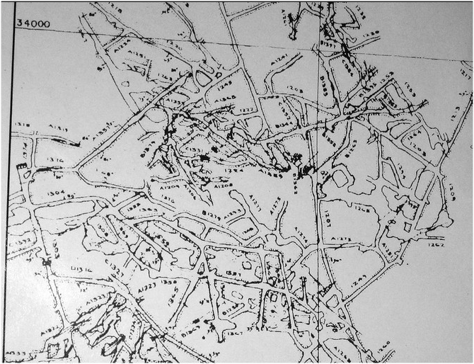
​Study the map of Nyeri (East Africa 1:50,000) to answer questions that follow(a) (i) what is the sheet number of the map extract. (1 mark) ü 120/ (ii) Give the longitudinal extent of the area covered by the map extract. (1 mark) ü From 36°45’E to 37°00’E
(b) (i) Give two reasons which show that the area receives high rainfall. (2 marks) ü Presence of forests ü Coffee production ü Presence of many permanent rivers/streams (Any 2x1mk =2mks) (ii Nametwo physical features found in the grid square 6246 (2 marks) ü River valley ü Steep slope ü spurs (c) Draw a rectangle 4 cm by 6 cm to represent the area north of Northing 60 and between Eastings 64 and 68. On it mark and label o River Amboni(Honi) o Road B5 o Mweiga township (5 marks) 
(d) Describe the drainage of the area covered by the map (4 marks)ü There are many permanent rivers ü The main drainage pattern is dendritic ü There are water holes ü There are many dams ü The main rivers are Amboni, Muringato,Chanya ü Most rivers are flowing from west to east (Any 4x1mk = 4mks)
(e) Students of Njogu-ini school wanted to do a field study on vegetation on the area covered by the map.(i) Identify two means of transport they are likely to use. ( 2 marks)ü Roads ü water (ii) Name three types of vegetation they are likely to identify (3 marks)ü Bamboo ü Scrub ü Thicket ü Forest ü Woodland (Any 3x1mk = 3mks) (iii) State three preparations they could make. (3 marks)ü conduct pre-visit/ reconnaissance ü Draw a route map ü Prepare working schedule ü Seek permission from school management ü Gather all the necessary tools (iv) Identify two problems they are likely to encounter. (2 marks)ü Difficult to access some areas due to thick vegetation (2mks) ü They might be scared/attacked by dangerous wild animals in the thickets ü Heavy downpour which might have interrupted the field study ü Fatigue ü Accidents from falls ü Uncooperative respondents ü Unable to identify some vegetation (Any 2x1mk = 2mks)
0 Comments
Study the map of Nyeri 1:50000 (sheet 12014) provided and answer the following questions. a) i) Give the longitudinal extent of the area covered by the map. 6) a) i) 360451E-370001E (2Marks) ii)What is the magnetic declination as at January 1975 of the map. 10311 (2Marks) b) i) Calculate the bearing of trigonometrical station in grid square 7546 from the forest guard station in grid square 6155. 1200 (2Marks) ii) Identify two types of vegetation found in Abedare forest. - forest -Bamboo (2Marks) d) Describe the drainage of the area covered by the map. -there are rivers -the rivers are permanent - The main river is river Chanya - Most of the rivers flow from western part of the area to eastern part. - The main river form dendritic pattern with it tributaries - There are some water holes - There are many dams e) With evidence from the map given four social function of Nyeri town. Social function Evidence - Administrative -PC,DC - Education –schools - Recreation –clubs, golf course - Communication - P.O f) Explain two factors favoring trade in Nyeri town - Availability of market evidence by many settlements. Good means of transport which facilitate movement of goods. Study the map of kijabe 1:50000 (sheet 134/3) provided and answer the following questionsa) (i) What is the map title for Kijabe? (1mk) East Africa 1:50000(Kenya) (ii) Give the approximate height of Kijabe Hill. (2mks) Above 2660m and below 2680M a.s.l (iii) Measure the distance of the dry weather road in the North- Western corner of the map. (Give your answer in kilometres) (2mks) 5.0km (+ 1) b) Draw a square measuring 10cm x 10cm to represent the area bounded by Easting 30 to 40 and Northing 90 to 00. On it mark and name: (5mks)
 c) ( i) Citing evidence from the map, identify the climatic conditions experienced in the area covered by the map. (4mks)
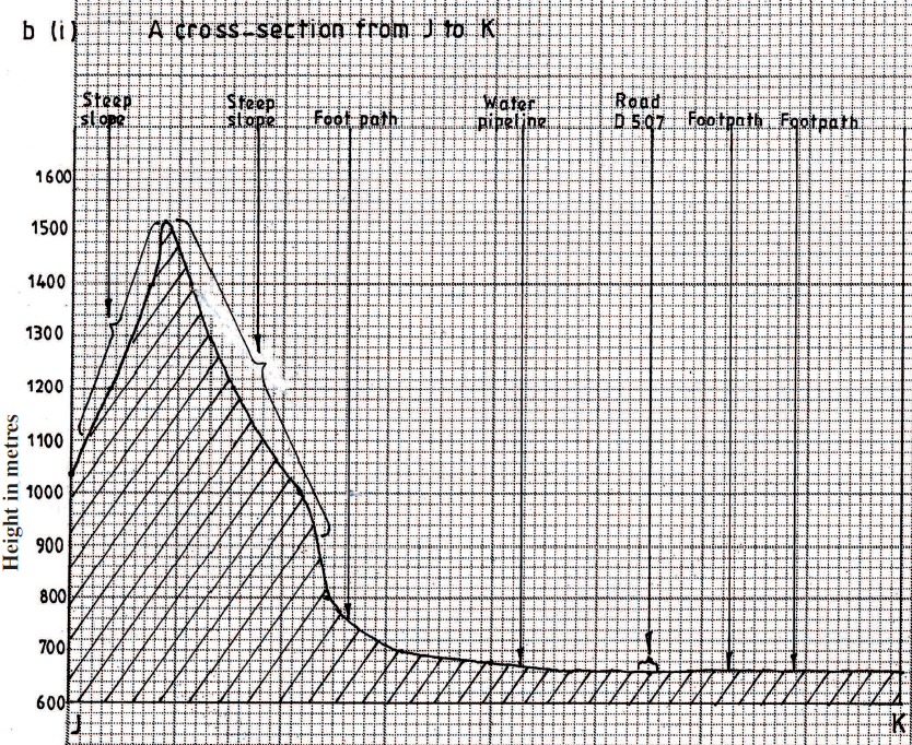
KCSE Geography Paper 1 2001 Section B Question 6. (i) What is the appropriate height of the top of Kijabe hill?
(ii) Measure the length of Nairobi – Naivasha railway line from landhies (grid reference 257978) to the level crossing near Kijabe station ( grid reference 308984). Give your answer in kilometers.
(iii) What relief feature on the map may have created problems in the construction of the railway line?
KCSE Geography Paper 1 2002 Section B Question 6.
i) What is the bearing of the trigonmetrical station at Grid reference 081980 from the rock out crop at grid reference 071992.
ii) Measure the length of the all – weather road (bound surface) b2 /1 from the junction at grid reference 947911 to the edge of the Map, grid reference 947667.(Give your answer in kilometers)
iii) On a rectangle, mark and name:

KCSE Geography Paper 1 2000 Section b Question 6 with Answers.Study the map of Mathioya 1: 50,000 provided and answer the following questions(a) (i) What is the bearing of the cattle dip at grid reference 716386 form the coffee factory at grid reference 740377?
(i) - 290 degrees
(ii) Give the approximate height of Kigoini dam
(ii) - 1000m above sea level
(iii) Measure the length of the district boundary in the Aberdare forest from Western margin of the map to the eastern edge of the forest (Give your answer in kilometers)
(iii) - 12.3 km or 12.2 km or 12.4 km
(b) Describe the drainage of the area covered by the map
Study the map of Menu (1: 50,000, sheet 108/3) provided and answer the following questions24/2/2021 KCSE Geography Paper 1 2003 Section B Question 6. Study the map of Menu (1: 50,000, sheet 108/3) provided and answer the following questions |

Archives
March 2024
Categories
All
|


 RSS Feed