|
The Lorian Swamp, also known as the Lorian Marsh, is a significant wetland area located in Kenya, East Africa. It is a vast expanse of marshes and swamps that are fed by numerous rivers and streams. One of the major rivers that flows into the Lorian Swamp is the Mara River, which holds great importance in the ecosystem of the region.
The Mara River originates from the Mau Escarpment in Kenya and meanders through the iconic Maasai Mara National Reserve before finally reaching the Lorian Swamp. The river serves as a lifeline for the diverse wildlife in the area and is renowned for the annual wildebeest migration, one of the world's most spectacular natural events. During this migration, thousands of wildebeest and other herbivores cross the Mara River in search of fresh grazing lands. The Mara River plays a crucial role in the ecosystem of the Lorian Swamp. It not only provides a source of water but also supports a rich variety of plant and animal life. The presence of the river ensures the availability of water throughout the year, sustaining the wetland habitat and its unique flora and fauna. The lush vegetation in the Lorian Swamp serves as a breeding ground for various bird species and provides a sanctuary for numerous amphibians, reptiles, and small mammals. Furthermore, the Lorian Swamp is home to a wide range of aquatic species, including fish, frogs, and water insects. These organisms rely on the swamp's nutrient-rich waters for their survival. The interconnectedness between the Mara River and the Lorian Swamp creates a delicate balance in the ecosystem, supporting the intricate web of life that thrives in this wetland habitat. In conclusion, the Lorian Swamp is a vital wetland area in Kenya, sustained by the Mara River. This vast marshland supports a diverse array of plant and animal life, including migratory species such as wildebeest. The river's flow provides a continuous water supply, creating a thriving ecosystem in the Lorian Swamp. Preserving and conserving this unique wetland habitat is crucial for the long-term sustainability of the region's biodiversity.
0 Comments
The longest river in Kenya is the Tana River. It stretches approximately 1,014 kilometers (630 miles) in length, making it the longest river in the country. The Tana River begins its journey in the Aberdare Range in central Kenya and flows eastwards towards the Indian Ocean. It passes through various landscapes, including forests, savannahs, and arid areas, before reaching its delta at the Indian Ocean near the town of Malindi.
The Tana River is of great importance to Kenya as it provides water for irrigation, hydroelectric power generation, and supports various ecosystems along its course. It is also a vital water source for agriculture, wildlife, and human settlements in the region. The river is home to a diverse range of flora and fauna, including several species of fish, crocodiles, and hippos. The Tana River has played a significant role in the history and development of Kenya, providing water for irrigation and power generation, as well as being a transportation route for goods and people. It is also a popular destination for activities such as white-water rafting and birdwatching. In conclusion, the Tana River is the longest river in Kenya, stretching over 1,014 kilometers. It is an important water source and supports various ecosystems and human activities along its course. The source of the Tana River is located in the Aberdare Range in central Kenya. The Aberdare Range is a mountain range that stretches across the central part of the country. It is a part of the Eastern Branch of the East African Rift System. The Tana River originates from the slopes of Mount Satima, which is the highest peak in the Aberdare Range, standing at an elevation of 4,001 meters (13,120 feet) above sea level.
From its source, the Tana River flows eastwards, meandering through the picturesque landscapes of the Aberdare National Park. It then continues its journey, passing through various regions and eventually forming the border between Tana River County and Tharaka Nithi County. As it progresses, the Tana River provides water to irrigation schemes, hydroelectric power generation, and sustains the diverse ecosystems along its course. The Tana River is a lifeline for many communities in Kenya, supporting agriculture, wildlife, and human settlements. It eventually reaches the Indian Ocean near the town of Malindi, forming a delta and providing important habitats for numerous aquatic species. In conclusion, the Aberdare Range in central Kenya is the source of the Tana River. The river plays a vital role in the livelihoods of people and the ecosystems it traverses, flowing from its origin in the Aberdare Range to its delta at the Indian Ocean. Freshwater Lakes in Kenya: Exploring the Ecological GemsFreshwater lakes are an important natural resource in Kenya, providing various ecological, economic, and recreational benefits. Kenya is home to several freshwater lakes, each with its own unique characteristics and significance. Here are some of the major freshwater lakes in Kenya:
What benefits would be there if more commuters in urban centres in Kenya used public transport?11/1/2024 The Pros and Cons of Increased Public Transport Usage for Urban Commuters in KenyaThe benefits of more commuters in urban centers in Kenya using public transport can be summarized as follows: Advantages of more commuters using public transport:
 Disadvantages of more commuters using public transport:Disadvantages of more commuters using public transport:
Problems Facing Urban Centers in KenyaUrban centers in Kenya face numerous challenges that hinder their development and sustainability. These problems arise due to rapid urbanization, inadequate infrastructure, and limited resources. In this essay, we will discuss four key problems facing urban centers in Kenya and their implications. Problems facing urban centres in Kenya:
The problems facing urban centers in Kenya are complex and require comprehensive solutions. Addressing the issues of inadequate housing, traffic congestion, inadequate basic services, and unemployment is crucial for the sustainable development of urban areas. Efforts should be made to improve infrastructure, promote affordable housing, enhance public transportation systems, and invest in education and skills development to alleviate these challenges. By addressing these problems, urban centers in Kenya can become more livable, inclusive, and prosperous for their residents.
State the factors that have favoured the rapid growth of Thika town as an industrial centre. (6mks)11/1/2024 The Factors Driving the Rapid Industrial Growth of Thika TownThika town in Kenya has experienced rapid growth as an industrial center due to several favorable factors. These factors have contributed to the establishment and expansion of various industries in Thika, making it one of the most industrialized towns in the country. This essay will discuss the key factors that have favored the rapid growth of Thika town as an industrial center. Factors that have favoured the rapid growth of Thika town as an industrial centre. (6mks)
The rapid growth of Thika town as an industrial center can be attributed to several favorable factors. Its strategic location, access to agricultural hinterland, availability of water resources, excellent transportation infrastructure, availability of land for industrial growth, and the congestion in Nairobi's industrial area have all played significant roles in attracting industries to Thika. As a result, Thika has emerged as one of the most industrialized towns in Kenya, contributing to economic growth and development in the region.
Understanding Urban Zoning and its Impact on Urban DevelopmentThe Central Business District (CBD) is a key zone within urban centers that plays a crucial role in economic activities and urban development. It is characterized by distinct features that set it apart from other zones within the city. In this essay, we will explore the characteristics of the Central Business Districts and understand their significance in urban planning and development. Characteristics of the central business districts.
The Central Business Districts are vital components of urban centers, serving as economic powerhouses and centers of commerce. Their characteristics, such as central location, high concentration of commercial activities, and vertical development, contribute to their significance in urban planning and development. Understanding these characteristics helps urban planners and policymakers in effectively managing and utilizing the CBDs to foster economic growth and create vibrant urban environments.
Apart from the central business district (CBD) name three other functional zones of a town. (3mks)11/1/2024 Exploring Functional Zones in Urban Centers: A Key to Understanding Urban DevelopmentUrban centers are divided into various functional zones based on their specific purposes and activities. The Central Business District (CBD) is just one of these zones. In this essay, we will explore three other functional zones commonly found in towns and discuss their characteristics and functions. Apart from the central business district (CBD) name three other functional zones of a town.
In addition to the Central Business District, towns are characterized by several other functional zones that contribute to their overall development and organization. The residential zone provides housing for residents, the industrial zone facilitates manufacturing and production, and the commercial zone serves as a center for trade and commerce. Understanding these functional zones is essential for effective urban planning and creating well-balanced and sustainable towns.
Factors Contributing to Urbanization and Town Growth: A Comprehensive AnalysisWhat is urbanization? (2mks) It is the process whereby there is an increase of the total population in a country settling in towns/changes from primary to secondary and tertiary production leading to growth of towns. Urbanization refers to the process of population growth and the shift of people from rural areas to urban areas, resulting in the development and growth of towns and cities. This process is characterized by various factors and activities that contribute to the expansion and transformation of urban centers. Here are some key points on the process of urbanization and how it leads to the growth of towns:
The Significance of Cocoa Production to Ghana's EconomyCocoa production plays a vital role in the economy of Ghana, contributing significantly to the country's foreign exchange earnings and providing employment opportunities for a substantial portion of the population. This essay explores the importance of cocoa production to Ghana's economy, highlighting its role in generating foreign exchange, improving infrastructure, creating employment, and enhancing the standard of living for cocoa farmers. Importance of cocoa production to the economy of Ghana. (3 mks)
In conclusion, cocoa production holds immense importance for the economy of Ghana. It serves as a major foreign exchange earner, contributing significantly to the country's export earnings. The revenue generated from cocoa exports is utilized to improve infrastructure and social amenities, creating a positive impact on the lives of cocoa farmers and the overall population. Additionally, cocoa production provides employment opportunities, reducing poverty and improving the standard of living for a significant portion of the working population. Ghana's reliance on cocoa highlights the significance of this agricultural commodity in driving economic growth and development in the country.
How cocoa is processed in Ghana (6 mks)
Cocoa processing in Ghana involves several steps to transform the harvested cocoa beans into various products. Here is a detailed explanation of the cocoa processing process in Ghana, based on the available documents:
Physical conditions that favor the growth of cocoa in Ghana. (3 mks)
The physical conditions that favor the growth of cocoa in Ghana are as follows:
Other than Ghana, name two countries in West Africa where cocoa is grown. (2 Marks)
Based on the information from the provided documents, the other countries in West Africa where cocoa is grown, in addition to Ghana, are:
Name two forces responsible for the geoid shape of the earthName two forces responsible for the geoid shape of the earth. (2mks)
The geoid shape of the Earth is determined by two forces: centripetal force and centrifugal force. Let me explain further:
Give three reasons why the interior of the earth is very hot. (3mks)
The interior of the Earth is very hot due to several reasons. Here are three reasons why:
River capture, also known as stream piracy or stream capture, refers to the natural diversion of the headwaters of one river into the channel of another river with greater erosional activity. It is an important geomorphic process that can reshape landscapes and alter river systems. To understand the conditions necessary for river capture to occur, we can refer to the information provided in the documents. State three conditions necessary for river capture to take place. (3mks)
In conclusion, river capture is a natural process that occurs when the headwaters of one river are diverted into the channel of another river with greater erosional activity. Three necessary conditions for river capture to take place include a difference in river levels, adjacent valleys and watersheds, and the presence of a wider valley and more active headward erosion in the pirate river. Understanding these conditions helps us comprehend the complex dynamics of river systems and their evolution over time.
River Capture: Features, Conditions, and Examples of this Natural PhenomenonDefine the term river capture (2mks) The diversion of the headwaters of a less powerful river into a more powerful river in an adjacent valley. River capture, also known as stream piracy or stream capture, refers to the natural phenomenon where the headwaters of a less powerful river are diverted into the channel of a more powerful river in an adjacent valley.
This process occurs when the tributaries of the more powerful river erode their source through headward erosion and capture the headwaters of the adjoining system. The captured river, also known as the misfit or underfit stream, loses its original headwaters and its flow is redirected into the channel of the capturing river. During river capture, several features and conditions can be observed:
In western Kenya, the Sondu River was captured by the Miriu River from the Asaw River, leaving a wind gap at the present Sondu market. River capture can also be observed in Europe, such as the capture of the upper Doubs from the Rhine and the capture of the former upper Meuse by the Moselle near Toul. In summary, river capture is the process by which the headwaters of a less powerful river are diverted into a more powerful river in an adjacent valley. It is characterized by features such as elbows of capture, drygaps, and river rejuvenation. Several conditions must be met for river capture to occur, including adjacent valleys, differential erosion, and active headward erosion. Human Activities and Climate Change: Understanding the Causes and ImpactsHuman activities have a significant impact on the Earth's climate, contributing to climate change and its far-reaching implications on the environment. Through the release of greenhouse gases, deforestation, industrialization, and energy consumption, humans have altered the delicate balance of the Earth's climate system. Understanding these activities and their consequences is crucial for developing sustainable solutions to mitigate the effects of climate change. Outline four human activities that contribute to climatic change. (4mks)
In conclusion, the four major human activities that contribute to climate change - greenhouse gas emissions, deforestation, industrialization, and energy consumption - have profound implications on the environment. These activities have led to rising global temperatures, melting ice caps, rising sea levels, changes in rainfall patterns, and increased frequency of extreme weather events.
The consequences of climate change are far-reaching, affecting ecosystems, agriculture, water resources, and human health. It is imperative that we take collective action to reduce greenhouse gas emissions, promote reforestation, adopt cleaner energy sources, and implement sustainable practices to mitigate the impacts of climate change and ensure a sustainable future for generations to come. The Four Orogenies in Geological History and their Fold MountainsWelcome to this comprehensive exploration of the four orogenies known in geological history and their corresponding fold mountains. In this content, we will delve into the time periods, specific examples, and significance of folding in creating these remarkable geological features. Join us as we uncover the fascinating world of orogenies and fold mountains. Name the four orogenies that are known in the geological history. (4mks)
In conclusion, the four orogenies known in geological history have played a significant role in shaping the Earth's landscape. From the ancient Charnian Orogeny to the more recent Alpine Orogeny, each period has left behind a legacy of fold mountains that continue to captivate and inspire. Understanding the formation and significance of these fold mountains provides valuable insights into the dynamic processes that have shaped our planet over millions of years. So, let us continue to explore and appreciate the wonders of geology and the remarkable stories written in the folds of these majestic mountains.
Formation of Fold Mountains: Unveiling the Role of Plate TectonicsFold mountains are majestic landforms that have captivated geologists and explorers for centuries. Understanding the process of their formation is crucial in unraveling the dynamic forces shaping our planet. According to the plate tectonics theory, fold mountains are primarily formed through the collision of tectonic plates. This article explores the key stages of fold mountain formation, providing a well-labeled diagram to illustrate the process. With aid of a well labeled diagram describe how fold mountains are formed according to the plate tectonics theory (7mks)
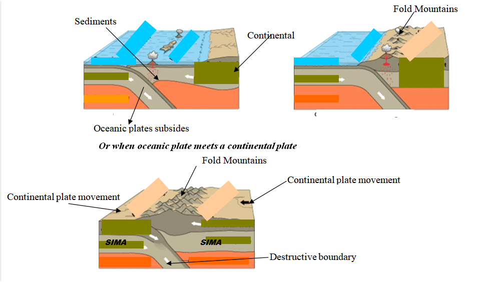 The plate tectonics theory provides a comprehensive explanation for the formation of fold mountains. Through the collision of tectonic plates, compression, folding, and uplift, these magnificent landforms emerge. The process is a testament to the immense forces at work beneath the Earth's surface. Understanding the formation of fold mountains not only enriches our knowledge of geological processes but also helps us appreciate the profound influence of tectonic activity on shaping our planet's landscapes.
The Influence of Fold Mountains on Climate: Exploring Four Key FactorsFold mountains are majestic geological formations that have a significant influence on climate patterns in the regions where they are found. These towering mountain ranges not only shape the landscape but also play a crucial role in determining local weather conditions. In this discussion, we will explore four key ways in which fold mountains influence climate, including solar radiation, wind patterns, rainfall distribution, and temperature variations. Explain four ways in which fold mountains influence climate (8mks)
Fold mountains have a profound influence on climate due to their topographic features and geographical positioning. The slopes of these mountains receive direct sunshine, leading to variations in solar radiation and temperature. The topography also affects wind patterns, creating local winds that can impact weather conditions. Additionally, the orographic effect causes variations in rainfall distribution, with windward slopes receiving more precipitation. Understanding the ways in which fold mountains influence climate is crucial for studying and predicting weather patterns in mountainous regions.
Unveiling the Forces of Wind Erosion in Deserts: Three Key Processes1.(a) Describe three ways in which wind erosion occurs in deserts. (6mks)
(b) With the aid of a well labeled diagram, describe the formation of the following features (i) Yardangs (6mks)
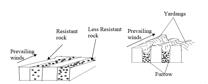 NB: TEXT = 4MKS, DIAGRAM 2 MKS NB: Diagram scores only if the direction of the prevailing winds and the arrangement of rocks are correct. (ii) Mushroom blocks. (6mks)
NB: Diagram scores only if the direction of the prevailing winds and the arrangement of rocks are correct. 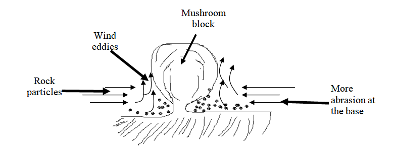 YOU INTEND TO CARRY OUT A FIELD STUDY ON DESERT LANDFORMS, STATE TWO OBJECTIVES OF YOUR STUDY.30/12/2023 You intend to carry out a field study on desert landforms, State two objectives of your study.(c)You intend to carry out a field study on desert landforms. a.State two objectives of your study. (2mks)
b.List three features formed through water action you are likely to identify (3mks)
c.Give two problems you are likely to encounter during the field study. (2mks)
The Significance of Vegetation: Exploring Distribution, Characteristics, and UsesDefine the term vegetation zone. (2mks) This is an expansive area having plant cover that gives it a distinct character. Vegetation zone refers to an extensive area that is characterized by a specific type of plant cover. It is a region where plants, including trees, shrubs, herbs, and grasses, grow together and create a distinct environment.
Vegetation zones are defined by the types of plants that dominate the area and are influenced by factors such as climate, soil conditions, and topography. These zones can vary in size and can be found at different scales, ranging from local ecosystems to global biomes. The vegetation within a zone plays a crucial role in shaping the physical and biological characteristics of the area, as well as providing habitat for various organisms. Understanding vegetation zones is essential for studying ecosystems, biodiversity, and the interactions between plants and their environment. |

Archives
March 2024
Categories
All
|


 RSS Feed
|
Primary Resources
College Resources
|
Secondary Resources
|
Contact Us
Manyam Franchise
P.O Box 1189 - 40200 Kisii Tel: 0728 450 424 Tel: 0738 619 279 E-mail - sales@manyamfranchise.com |