ATIKA SCHOOL
  • Start
    • SITEMAP
    • KNEC Portal
    • ZERAKI HELP AND SUPPORT
    • Academic Environment
    • KNEC KCSE PROJECT INSTRUCTIONS
  • BLOGS
    • About Us? >
      • Learn more about us
    • CUSTOMER CARE >
      • PRICING
      • Help & Support
    • News and Opinions
    • JOBS IN KENYA AND ABROAD FOR KENYANS AND BEYOND
    • How its Done
  • OUR PRODUCTS
    • All Categories >
      • MORE PRODUCTS >
        • SECONDARY CRE NOTES
        • COURSE BOOKS
        • KCSE KISWAHILI SETBOOKS
        • Backed Up Files and Archives
        • FREE DOCUMENTS
        • PRIMARY 8-4-4 BASED RESOURCES
        • STANDARD 8 RESOURCES
        • HIGH SCHOOL RESOURCES >
          • Biology Paper 3 Exams
          • Secondary Examinations
        • PRIMARY CBC BASED RESOURCES
        • COLLEGE & VARSITY RESOURCES
      • PRIMARY RESOURCES CBC
      • PRIMARY RESOURCES 8-4-4
      • SECONDARY RESOURCES
      • NOTES & TUTORIALS
      • COLLEGE RESOURCES
      • NOVELS and OTHER BOOKS
    • EXAMINATIONS >
      • MOCKS AND JOINT EXAMS >
        • FORM 1 QUESTION PAPERS, ANSWERS AND MARKING SCHEMES COLLECTIONS
        • FORM 2 QUESTION PAPERS, ANSWERS AND MARKING SCHEMES COLLECTIONS
        • FORM 3 EXAMINATIONS, QUESTION PAPERS AND ANSWERS
        • FORM 4 MOCKS PAST EXAMS BY REGION
        • TOP SECONDARY EXAMS ALL SUBJECTS
      • KPSEA NATIONAL EXAMS
      • KCPE >
        • KCPE PAST PAPERS AND ANSWERS >
          • KCPE 2020 RESULTS, REPORTS, QUESTIONS AND ANSWERS
          • KCPE PAST PAPERS 2019 REPORTS, RESULTS, QUESTIONS AND ANSWERS
        • KCPE PAST PAPERS PER SUBJECT
      • KCSE >
        • KCSE PAST PAPERS BY SUBJECT
        • KNEC KCSE PAST PAPERS, MARKING SCHEMES, QUESTIONS & ANSWERS
        • Free KCSE Past Papers Mathematics
        • Free KCSE Biology Questions and Answers
      • QUESTIONS & ANSWERS >
        • SECONDARY >
          • LANGUAGES >
            • Secondary English Questions and Answers
          • TECHNICALS >
            • COMPUTER STUDIES >
              • COMPUTER STUDIES Q & A
              • kcse computer studies paper 2 AND 3 Questions & Answers
            • BUSINESS STUDIES QUESTIONS & ANSWERS
            • KCSE AGRICULTURE TOPICAL QUESTIONS AND ANSWERS
            • KCSE HOME SCIENCE DIRECT QUESTIONS AND ANSWERS
          • SCIENCES >
            • KCSE Mathematics Topical Questions
            • KCSE Biology Topical Questions and Answers
            • CHEMISTRY TOPICAL QUESTIONS AND ANSWERS
            • KCSE Physics Topical Questions
            • KCSE physics Practical Sample Quiz
          • HUMANITIES >
            • C.R.E (CRE) QUESTION AND ANSWERS
            • ISLAMIC RELIGIOUS EDUCATION (IRE) QUESTIONS AND ANSWERS
            • KCSE History Topical Questions and Answers
            • GEOGRAPHY TOPICAL QUESTIONS AND ANSWERS
        • PRIMARY >
          • Standard 4-8 Mathematics Topical Questions from Mocks and KCPE
          • Std 6 Mathematics Notes
    • TUTORIALS >
      • SECONDARY >
        • SCIENCES >
          • FOCUS MATHEMATICS TUTORIALS AND EXAMS FREE
          • KCSE BIOLOGY NOTES
          • FREE KCSE CHEMISTRY NOTES
          • KCSE PHYSICS NOTES, AUDIOVISUALS AND MORE
        • LANGUAGES >
          • ENGLISH >
            • A GUIDE TO SILENT SONG AND OTHER STORIES
            • English KCSE Set Books
            • ENGLISH POETRY QUESTIONS WITH ANSWERS FOR K.C.S.E CANDIDATES
            • ENGLISH GRAMMAR #KCSE
          • KISWAHILI >
            • Bembea ya Maisha
            • CHOZI LA HERI - MWONGOZO
            • KIGOGO - MWONGOZO
            • MASWALI NA MAJIBU YA TUMBO LISILOSHIBA
            • USHAIRI MASWALI NA MAJIBU
            • KCSE Kiswahili Fasihi
        • TECHNICALS >
          • HOME SCIENCE NOTES
          • KCSE BUSINESS STUDIES NOTES
          • COMPUTER STUDIES NOTES LATEST
          • kcse Computer Studies Notes
          • KCSE AGRICULTURE NOTES, SYLLABUS, QUESTIONS, ANSWERS, SCHEMES OF WORK AND OTHERS
        • HUMANITIES >
          • KCSE History Notes Form 1 to 4
          • FREE KCSE CRE NOTES
          • KCSE GEOGRAPHY NOTES
          • IRE NOTES, AUDIOVISUAL, QUESTIONS AND ANSWERS
      • PRIMARY >
        • STANDARD 4: SOCIAL STUDIES
        • NOTES >
          • KISWAHILI
          • SOCIAL STUDIES
        • EXAMINATIONS
        • DecaTurbo Online Series Examinations
        • KCPE Mathematics Notes
        • KCPE and Primary Level Compositions
      • Other Supportive Documents >
        • SYLLABUS >
          • Primary 8-4-4 based Syllabus, Objectives and Lessons
          • Primary Mathematics Syllabus
        • MASOMO VIDEOS
    • CURRICULUM >
      • NEW CURRICULUM DESIGNS >
        • PRIMARY >
          • PRE PRIMARY ONE CURRICULUM WITH SYLLABUS
          • PRE PRIMARY TWO CURRICULUM WITH SYLLABUS
        • SECONDARY >
          • KNEC KCSE SYLLABUS AND COURSE OUTLINES
        • COLLEGE >
          • Regulations for the TIVET Craft and Diploma Business Examinations
    • HIGH INSTITUTIONS >
      • EXAMINATIONS >
        • College and Varsity Past Papers online
      • TUTORIALS >
        • COLLEGE AND UNIVERSITY NOTES AND TUTORIALS
  • MEMBERS RESOURCES
    • Primary >
      • CBC AND 8-4-4 LATEST EXAMS
      • CBC PROFFESSIONAL TOOLS
      • CBC NOTES PRIMARY
      • CBC KPSEA EXAMS
      • Standard 8 (std) English Topical Questions
      • KCPE MATHEMATICS TOPICAL QUESTIONS FROM 1989 TO LAST YEAR
      • STANDARD 8 PAST PAPERS 8-4-4 BASED
    • Secondary >
      • FORM 1 EXAMS WITH ANSWERS
      • FORM 2 EXAMS WITH ANSWERS
      • FORM 3 EXAMS WITH ANSWERS
      • FORM 4 EXAMS WITH ANSWERS
      • KCSE 2020 QUESTIONS AND ANSWERS
      • NOTES SECONDARY
      • MOCKS SECONDARY >
        • kcse form 2 mathematics questions
    • Free Schemes of Work
    • FOCUS A365 SERIES K.C.P.E EXAMINATIONS FOR PRIMARY
    • ALL GROUPS PRODUCTS
    • PREMIUM PRODUCTS 2

GEOGRAPHY TOPICAL QUESTIONS AND ANSWERS

TERM ONE 2021 CaSPA AMUKURA PARISH EXAM GEOGRAPHY PAPER 1 FORM 4 2021 QUESTION PAPER AND MARKING SCHEME

6/8/2022

0 Comments

 
​SECTION A
Answer all questions in this section.
1. a) Explain the origin of the earth and the solar system according to the Nebula cloud theory.
(4mks)
b) Name two other theories that explain the origin of the earth and the solar system apart from the Nebula cloud theory. (2mks)

2. a) List two zones of transition in the atmosphere. (2mks)
b) Give three evidences that the interior of the earth is hotter. (3mks)

3. a) Define the following terms.
i) River divide (1mk)
ii) A confluence (1mk)
iii) A river profile (1mk)
b) List three factors that influence the formation of a river. (3mks)

4. How is an oasis formed? (4mks)

5. List four characteristics of Mediterranean climate. (4mks)

SECTION B: Answer questions six and any other two questions.
6. (a) Study the map of Kijabe 1: 50,000 sheet 134/3 provided and answer the following questions
             (i) Give the approximate height of peak of Kijabe hill.                (1mk)
(ii) Measure the length of the Naivasha –Nairobi railway line from landhies (Grid ref 257987) to    
            the level crossing near Kijabe station (grid reference 308984). Give your answer in kilometers and     
            Meters.)                                                                                                   (2mks)
(iii) Name the relief feature on the map that may have created problems during the construction of     
            the railway line.                                                    (1mk)

(b) Describe the drainage of the area covered by the map extract.   (5mks)
           (c) Explain how relief has influenced the distribution of settlement in the area covered by the 
map extract.   (4mks)
         (d) Citing evidence from the map, state four economic activities carried out in the area 
  
      covered by the map extract.             ( 4 mks)
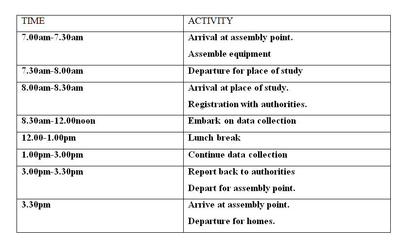
            (e) Suppose you were to carry out a field study at Wakangwe forest:
            (i) Design a working schedule that you would use during the day of the study.             (5mks)
(ii) Give reasons why it would be necessary to sample part of the forest for the study.       (2mks)                                                          
(iii) State two ways in which your findings would be useful to the local community.         (2mks)

7. a) i) What is faulting?                (1mk)
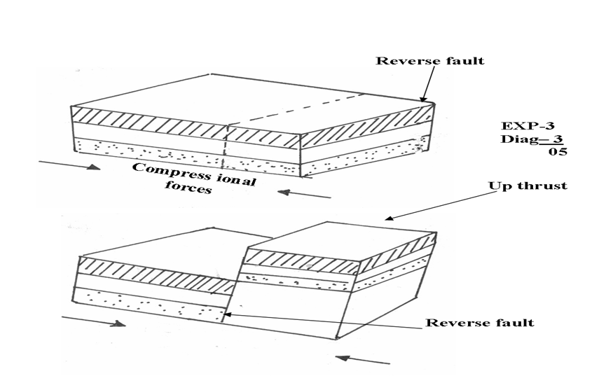
ii) With the use of a well labeled diagram explain how a reverse fault occurs.   (5mks)
iii) State two other types of faults apart from reverse faults.   (2mks)
b) Describe how a rift valley forms through tensional forces.   (4mks)
c) Explain three ways in which features resulting from faulting are of economic importance to man. (6mks)
d) You intend to carry out a field study of the landforms around your school.
i) State two hypotheses you are likely to formulate for the study. (2mks)
ii) Apart from dividing your class into groups, in what three other ways will you 
prepare for the study.                                                                           (3mks)
ii) In what two ways is dividing the class into groups important? (2mks)

8. a) i) Differentiate between intrazonal and azonal soils. (2mks)
ii) Give three examples of a zonal soils (3mks)
b) i) Explain four factors that influence soil formation. (8mks)
ii) Give two factors that determine the colour of soil (2mks)
c) i) What is soil erosion. (2mks)
ii) Explain four ways in which vegetation prevents soil erosion. (8mks)

9 a) i) Name a country in Africa where temperate grassland is found. (1mk)
ii) State four characteristics of temperate grasslands. (4mks)
b)        i) Explain four ways trees in the coniferous forests have adapted to the 
environmental conditions of the region.                                                (8mks)
c) You are required to carry a field study on a forest near your school. Describe the methods 
you would use to determine each of the following aspects of the trees in the forest.
i) Age of the trees. (3mks)
ii) Height of the trees. (3mks)

iii) Tree species (3mks)


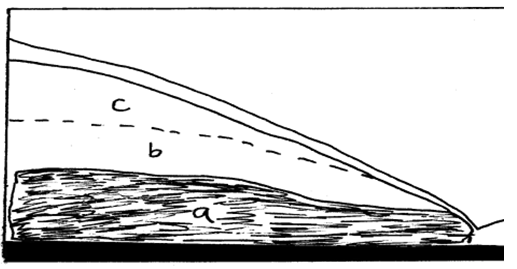
10. The figure below shows underground zones of saturation.  Use it to answer question a (i)
Picture
a) i) Identify the zones marked a, b, and c. (3mks)
ii) Name four sources of groundwater. (4mks)
b) Explain four ways in which groundwater is of significance to human activities. (8mks)

c) i) Give two examples of lakes in East Africa that have formed due to crustal 
warping. (2mks)
ii) Describe how the process of crustal warping leads to formation of lakes. (5mks)
iii) State three other processes that lead to formation of lakes apart from crustal 
warping.
​

MARKING SCHEME

SECTION A
1. a) Origin of the solar system and the earth according to the Nebular Cloud Theory
- There existed a big cloud ✓ (Nebular of hot gases and dust)
- This cloud which was rotating at a very high speed ✓ flattened into a disk due to centrifugal force.✓
- Very hot materials concentrated at the centre✓ of the rotating cloud and led to the formation of the sun
- Some masses of gases and dust were thrown off as ✓ the cloud continued to rotate 
- The particles consolidated, cooled and contracted to form planets✓ 1 x 4 = 4mks
b) Other theories
- The twin star theory/ big bang✓
- The passing star theory✓
- Biblical/ creation theory✓                                                                      1 x 2 = 2mks

2. a) Transitional zones of the atmosphere
- Tropopouse
- Stratopause✓
- Mesopause✓ 1 x 2 = 2mks
b) Evidences that the interior of the earth is hotter 
- During volcanic eruptions hot material (magma) are ejected onto the surface✓
- Occurrence of hot springs on the ground✓
- Progressive increasing heat experienced as mines and borings get deeper✓
- The molten state of rocks in the mantle✓
1 x 3 = 3mks
3. a) Defining
(i) River divide – It is a ridge line/ hill ground that separates two or more river basins✓
(ii) A confluence – The point at which a tributary joins the main river✓
(iii) A river profile – This is the longitudinal cross section of a river from the source to the mouth.✓
1 x 3 = 3mks
b) Factors that influence the formation of a river
- Vegetation cover✓
- Climate✓
- Nature of rocks✓
- The degree of slope✓
- Land use systems e.g. irrigation✓
1 x 3 = 3mks
4. How an oasis forms
- A pre-existing depression is deepened by eddy action/ deflation✓
- Gradually the depression is excavated through wind abrasions✓
- The surface is lowered until it reaches the water bearing rock/ aquifer / table
- Water oozes out of the ground and collects in the depression to form an oasis✓
1 x 4 = 4mks
5. Characteristics of mediterranean  climate
- Summers are hot with temperatures of about 210C✓
- Winters are mild/ cold with temperatures of about 110C✓
- Mean annual rainfall moderate varies between 500 – 900 mm with most of it falling in winter✓
- The region mainly experiences cyclonic rainfall✓
- Trade winds are offshore in summer and onshore westerlies dominate in winter✓
- Hot and cold local winds are common✓
1 x 4 = 4mks
Total = 25 marks

SECTION B
6. (a) Study the map of Kijabe 1: 50,000 sheet 134/3 provided and answer the following questions
             (i) Give the approximate height of peak of Kijabe hill.                (1mk)
● 2260m- less than 2280m.
(ii) Measure the length of the Naivasha –Nairobi railway line from landhies (Grid ref 257987) to the level crossing near Kijabe station (grid reference 308984). Give your answer in kilometers and   Meters.)                                                                                      (2mks)
● 5 kilometres 600metres. (5.6km is wrong for the requirement of the question.)

(iii) Name the relief feature on the map that may have created problems during the construction of the railway line.                                                    (1mk)
● Hill

(b) Describe the drainage of the area covered by the map extract.   (5mks)
● The main drainage feature are rivers.
● The main river is R.Ewaso Kedong.
● The area has disappearing rivers.
● The area has radial drainage pattern.
● Most rivers display dendritic drainage pattern
● The area has a water trough.
● The area has water holes.                                                  (5*1mk)
(Student scores without giving the reference on the map-the question has not asked “giving evidence from the map”)
           (c) Explain how relief has influenced the distribution of settlement in the area covered by the 
map extract.   (4mks)
● Steep slopes have few settlements to the north west/around Kijabe hill.
● Gentler slopes have attracted higher settlements e.g. around Magina.(Any 2*2mks)
         (d) Citing evidence from the map, state four economic activities carried out in the area 
      covered by the map extract.             ( 4 mks)
● Trade-Presence of shops
● Livestock rearing-Presence of cattle dips/dairy(This is one  marking point)
● Tourism-Presence of hot springs.
● Transport-Presence of roads.
● Lumbering-Presence of a sawmill.
● Manufacturing-Presence of carbacid plant.
● Quarrying-Presence of a quarry.

            (e) Suppose you were to carry out a field study at Wakangwe forest:
            (i) Design a working schedule that you would use during the day of the study.             (5mks)
​
Picture
​(ii) Give reasons why it would be necessary to sample part of the forest for the study. (2mks)    
● To save time by reducing the area to be covered.
● To reduce fatigue for the participants by reducing area to be covered by individuals.
● To ensure thorough scrutiny of the sampled area.
                                                      
(iii) State two ways in which your findings would be useful to the local community.     (2mks)
● Will form basis for future research.
● Will reveal the importance of forests to the general community hence forest conservation.

7. a) (i) What is faulting
- It is the fracturing/ cracking of crustal rocks ✓1
    (ii) Formation of reverse fault
- Formed when crustal rocks are exposed to compressional forces✓
- A reverse fault develops ✓
- Continued pushing of compressional forces lead tone block being pushed over the other to form a reverse fault ✓
Picture
​  (iii) Other types of faults
- Normal faults✓
- Shear/ tear/ slip/ strike slip/ wrench/ trancurrent✓
- Thrust fault/ over throw✓
- Anticlinal faults✓ 1 x 2 = 2mks
b) How a rift valley forms through tensional forces
- Layers of rocks in a region are subjected to tensional forces✓
- Lines of weakness develop, resulting in the development of normal faults✓
- As the forces pull the side blocks away, the middle block sinks✓
- The block that has sunk forms the floor of the rift valley ✓ 1 x 4 = 4mks
c) Economic importance of features formed through faulting
- Block/ horst mountains are a source of rivers which provide water for HEP production e.t.c✓✓
- Rift valley formation has led to the exposure of minerals e.g. diatomite which are mined on the rift valley floor✓✓
- Rift valley lakes formed through faulting are important fishing grounds ✓✓
- Faulted features provide scenery which promote tourist industry✓✓
- Block mountains attract rainfall which favour agriculture/ settlement✓✓
2 x 3 = 6mks
d) (i) Hypotheses
- Most landforms near my school have resulted from faulting✓
- Presence of block mountains around my school has influenced tourism✓
- Mountains are the dominant landforms around my school✓ Any relevant points 1 x 2 = 2mks
    (ii) Other ways of preparing for the study
- Seeking permission from relevant authorities✓
- Conducting a pre-visit/ reconnaissance✓
- Preparing a questionnaire✓
- Holding discussions in class✓
- Preparing a working schedule✓
- Reading through relevant books✓
- Gathering the required tools✓ 1 x 3 = 3mks
     (iii) Importance of dividing into groups
- It eases congestion/ overcrowding in areas they have to visit✓
- It helps in ensuring that required data is collected within the time frame given✓
- It creates order when carrying out the field study✓
- Ensures that everybody is involved in the study✓ 1 x 2 = 2mks
Total = 25 marks

8. a) (i) Difference between intrazonal and azonal soils
- Intrazonal soils are those soils that are formed under poor drainage conditions e.g. water logged areas whereas azonal soils are those soils that have not had adequate time to develop. They are thus immature soils.✓✓
The difference must come out clearly to score
   (ii) Examples of azonal soils
- Mountain/ scree soils✓
- Alluvial soils✓
- Glacial soils✓
- Loess✓
- Volcanic soils recently formed✓
b) (i) Factors that influence soil formation
- Parent rock✓F 
Nature of the rock influences the rate of weathering ✓EX hard rocks weather slowly while soft rocks weather fast
The rock determines the soil texture e.g. large grained rocks produce large grained soils
- Living organisms✓F
They assist in the breaking down of rocks through burrowing ✓EX
The roots of bigger plants break up the soil as they grow and allow water to pass through
- Topography✓
It determines the rate of weathering e.g. steep slopes encourages high rate of weathering✓EX
It influences soil depth e.g. gentle slopes have deep soils while steep slopes have thin soils
It influences soil drainage e.g. where land is flat soils are poorly drained
- Climate✓F
Affects the rate and type of weathering that takes place ✓EX
Determines the rate of leaching
Elements of climate i.e. Temperature accelerates weathering leading to soil formation
- Time✓F
For soil to reach maturity, time is required✓EX
F = max 04 EX = max 04 Total = 8mks
      (ii) Type of parent material✓
            Chemical composition of the soil✓
Drainage of the area✓
c) (i) What is soil erosion
         The process by which the top soil is removed/ detached and carried away ✓✓ by various agents at a rate that is faster than it is being replaced by the soil forming processes
    (ii) Way vegetation prevents soil erosion
- The leaf cover helps to reduce the force of raindrops which would otherwise loosen and remove soil particles if the force is not checked✓✓
- The rate of infiltration of rainwater into the soil is increased by vegetation cover thus reducing surface run off ✓✓
- Plant cover breaks the force of wind at the ground level and reduces the transportation of soil particles/ reduces the evaporation which would dry and loosen the soil✓
- Decayed vegetation matter provides humus which binds the soil particles together✓ 2 x 5 = 10mks
Total = 25 marks

9. a) (i) A country in Africa where temperate grassland is found
- South Africa✓1
    (ii) 4 characteristics of temperate grasslands 
- Treeless except along water courses ✓
- Grass is short and tough in the drier areas✓
- Grass is tall in the moist areas✓
- Grass withers in Autumn and dies in Winter✓
- Grass sprout in springs✓
- Grass is nutritious✓
1 x 4 = 4mks
b) (i) Ways in which trees in the coniferous forests have adapted to the environmental conditions
- The trees have a conical shape and flexible branches to allow snow to slide off easily thus minimizing damage to the trees✓✓
- Most trees are evergreen so as to have maximum utilization of sunlight during the short drowing season ✓✓
- Needle like leaves help to reduce the loss of water from the trees in winter when there is no moisture to be absorbed from the soil✓✓
- The tree trunks are flexible to enable them sway without breaking during the strong winter winds.✓✓
- The leaves have a tough waxy skin which protects them from the winter cold✓✓
- The trees have a widely spread root system for utilizing moisture from the top soil since most of the time the subsoil is frozen✓✓
2 x 4 = 8mks
   (ii) Factors that determine zoning of mountain vegetation
- Altitude✓
- Aspect✓
- Slope✓
- Temperature✓
- Moisture availability✓
1 x 3 = 3mks
c) (i) Methods likely to be used in determining:
I. Age of trees
- Asking the local people / forest officer / when the trees may have been planted✓
- Observing the rings on the tree stump and counting them to find out the age of the trees✓
- By estimating the age of trees
- Refering to available records to know when the trees were planted
1 x 3 = 3mks
II. Height of trees
- By estimating the height ✓
- By measuring the exact height of samples of trees and generalising✓
- Calculate using the ratio of height of near short object in relation to height of its, relate to the shadow of the tree in relation to its height.
1 x 3 = 3mks
III. Tree species
- By walking through the forest observing and noting the various species ✓
- By interviewing the local people / forester✓
- By reading through available records✓ 1 x 3 = 3mks
Total = 25 marks

10. a) (i) The zones marked
a – zone of permanent saturation/ phreatic zone✓
b – zone of intermittent saturation✓
c – zone of non – saturation ✓ 1 x 3 = 3mks
    (ii) Sources of ground water
- Rain water✓
- Lake/ sea water✓
- Melt water✓
- Magmatic/ plutonic water✓ 1 x 4 = 4mks
b) Significance of ground water
- Sources of rivers – Many springs are sources of river that provide water for industrial / domestic use ✓✓
- Ground water is used for irrigating the land all over the world thus promotes agriculture✓✓
- Ground water influences the development of settlements✓✓
- Hotsprings are a tourist attraction✓✓
- At the mouths of many hotsprings, valuable mineral salts are deposited and people exploit them for economic gain✓✓
2 x 4 = 8mks
c) (i) Lakes that have formed due to crustal warping in East Africa
- Lake Victoria✓
- Lake Kyoga✓
- Lake Wamala✓
- Lake Kachira✓
1 x 2 = 2mks
   (ii) How crustal warping leads to the formation of lakes
- Earth movements cause crustal downwarping ✓
- This leads to the formation of a basin like depression✓
- Uplifting of landmasses around the depression diverted the flow of rivers into the depression causing reversed drainage✓
- Deposition onto the depression resulted in to further downwarping✓
- Water from the rivers accumulated in the depression to form a lake✓
1 x 5 = 5mks
   (iii) Other processes that lead to formation of lakes
- Faulting✓
- Vulcanicity✓
- Erosion✓
- Deposition✓
- Meteorite falling✓
- Human activities✓
1 x 3 = 3mks
Total = 25 marks
0 Comments

Give two reasons why petroleum refinery industry is located at Mombasa

8/10/2021

0 Comments

 
Give two reasons  why petroleum refinery industry is located at Mombasa 
  • Proximity of the harbour and Mombasa port
  • Availability of plenty of water used in petroleum refinery

Read More
0 Comments

Identify three types of pollution

7/10/2021

0 Comments

 
Three types of pollution
  • Soil 
  • Water 
  • Air 
  • Sound / Noise
  • Land 
  • Radiation 

Read More
0 Comments

Explain four reasons as to why it is important to conserve and manage the environment

7/10/2021

0 Comments

 
The importance of environmental conservation and management
  • Protection of endangered species 
  • Economic value 
  • Food supply
  • Aesthetic value
  • Protection of water catchment areas
  • To reduce pollution 
  • Proper utilization of resources.

Read More
0 Comments

The table below shows the value of cash crops produced in Kenya over a period of six years in (‘000) Kenya shillings.

7/10/2021

0 Comments

 
The table below shows the value of cash crops produced in Kenya over a period of six years in (‘000) Kenya shillings.

​i) Using the data provided above draw a comparative line graph to represent this information

  • Title (1 mark)
  • Scale (1 mark)
  • Labelling – y-axis ( ½ mark)
  • x-axis ( ½ mark)
  • Trend / plotting (2 marks)
  • Clarity & key (1 mark) 

​ii) Which year was the total value of the cash crops the highest? How much was it? 

  • Year 2007
  • Ksh. 40,100,000 million.

​iii) Which year experienced the greatest slump in total production of cash crop and why?

  • Year 2008
  • Due to the effects of Post election violence 

​iv) Give four merits of using comparative line graph to represent data

  • Easy to trace the trend of each variable 
  • Easy comparison between variables can be made
  • The graph is easy to read and interpret.
  • Gives a clear visual impression.

Read More
0 Comments

Differentiate between renewable and non renewable sources of energy

7/10/2021

0 Comments

 
Difference of renewable and non-renewable sources of energy.
​Renewable sources
​Non renewable
  • ​are those that are continuously replaced or regenerated e.g. solar, H.E.P, Wind, Tidal, Wave Biomass, wood and charcoal.
  • ​sources are those that are finite or cannot be regenerated. They are exhaustible e.g petroleum (fossil fuel), natural gas and coal and uranium

Read More
0 Comments

What is eco – tourism

7/10/2021

0 Comments

 
What is eco- tourism 
This refers to tourism which involves the environmental conservation – This is sustainable tourism.
Ecotourism is defined as responsible travel to natural areas that conserves the environment, sustains the well-being of the local people, and involves interpretation and education

Read More
0 Comments

State four factors which influenced the distribution of wildlife in East Africa

7/10/2021

0 Comments

 
State four factors influencing distribution of wildlife in E. Africa
  • Climate 
  • Vegetation 
  • Altitude
  • Soils 
  • Drainage 
  • Human activities 

Read More
0 Comments

Name any two fishing grounds of the world

7/10/2021

0 Comments

 
Name any two fishing grounds of the world. 
  • N.E Atlantic
  • N.W Atlantic
  • N.E Pacific 
  • N.W Pacific

Read More
0 Comments

Apart from water and air pollution, name two other types of pollution

1/3/2021

0 Comments

 
KCSE Geography Paper 2 2001 Section B Question 9.

​(a) (i) Apart from water and air pollution, name two other types of pollution.

  • Land pollution/ soil. Ground
  • Noise pollution/ sound
  • Thermal pollution
  • Radiation

​(ii) Identify three ways through which water is polluted

  • Discharge of industrial waste/ oil spillage/ radioactive waste into water bodies
  • Disposal of domestic waste into  water bodies
  • Discharge of agriculture chemicals into rivers/ lakes by rain water
  • Discharge of raw sewage  into water bodies
  • Abuse of water bodies by human beings
  • Natural causes e.g. soil erosion/ terrestrial gas

​(iii) Explain three effects of air pollution on the environment

  • Gases emitted from some factories contain substances which corrode roofs of houses and mental structures
  • Some gases from factories contain substances which dissolve in  water to form acid  which make  plants maim or kill animals
  • Inhalation for smoke and soot particles / bad smell lead to discomfort / irritation of the respiratory system / discolouring of vegetable / building.
  • Gases emitted from factories may contain poisonous substance which can lead to poor health / death when inhaled /plant leaves turn yellow.
  • Gases / excess carbon dioxide increases the temperature affecting the climate of the affected areas / depletion of O – Zone layer.
  • Smoke / dust / smog reduces visibility which way lead to motor accidents.
  • Dust particles that settles on leaves inhibits photosynthesis
(a) (i) Apart from water and air pollution, name two other types of pollution (ii) Identify three ways through which water is polluted (iii) Explain three effects of air pollution on the environment (b) (i) Explain three factors that lead to frequent flooding in the lake region of Kenya (ii) Explain two ways through which floods are controlled in the lake region of Kenya (c) State four effects of wind as an environmental hazard in Kenya

Read More
0 Comments

Below a sketch of the map of the great lakes- St. Lawrence Seaway. Use it to answer question (a)

1/3/2021

0 Comments

 
KCSE Geography Paper 2 2001 Section B Question 8.

Below a sketch of the map of the great lakes- St. Lawrence Seaway. Use it to answer question (a).

 Below a sketch of the map of the great lakes- St. Lawrence Seaway. Use it to answer question (a) (a) Name (i) The lake marked L (ii) The waterfall marked M (iii) The port marked N (b) Explain three ways in which the great lakes St. Lawrence sea way has contributed to the economy of Canada and the United States of America ( U.S.A) (c) Explain four factors that hinder the development of railway links among Africa countries (d) (i) State two recent development that have taken place in Kenya to improve Communication of information (ii) Explain three problems facing telephone as a means of communication in Kenya

​(a) Name (i) The lake marked L

  • Lake Superior

​(ii) The waterfall marked M

  • Niagara falls

Read More
0 Comments

Explain four problems that Mombasa experiences as it grows

1/3/2021

0 Comments

 
KCSE Geography Paper 2 2001 Section B Question 7.

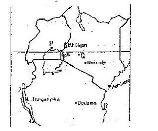
​Use the map of East Africa below to answer questions

(c) Compare the ports of Mombasa and Rotterdam under the following subheadings (i) Transport links to the interior (ii) Mechanization of the ports (iii) Size of the ports (iv) Climate experienced at the ports

​(a) Name the towns marked P,Q and R

  • P – Kampala
  • Q – Nakuru
  • R- Dar – el- Salaam

​(b) (i) Explain three physical factors that influence the location of Mombasa

  • Its strategic position of the East coast of Africa was an ideal calling point for traders to and from the far East
  • The island provides a good defensive site against external threats
  • The flat land was ideal for construction  of  buildings
  • The deep water on Mombasa and Kilindini channels provided a natural harbour for traders
  • Rivers Mwachi / Kombeni provided fresh water for domestic use
  • The coral limestone found in the area was used as building stones for houses

Read More
0 Comments

Study the photograph below and use it to answer questions (a)

1/3/2021

0 Comments

 
KCSE Geography Paper 2 2001 Section B Question 6.

​Study the photograph below and use it to answer questions (a)

Study the photograph below and use it to answer questions (a) (a) (i) Name the type of photograph shown (ii) Draw a rectangle measuring 15cm to 10cm to represent the area of photograph (iii) On the rectangle draw a sketch of the photograph and label three physical features (iv) Explain two physical conditions that would discourage setting up of a game park in the area shown on the photograph

​(a) (i) Name the type of photograph shown

  • Ground  photograph/ ground general view

​(ii) Draw a rectangle measuring 15cm to 10cm to represent the area of photograph.

​(ii) Draw a rectangle measuring 15cm to 10cm to represent the area of photograph.

Read More
0 Comments

Give three effects of liberalization of the oil industry in Kenya.

1/3/2021

0 Comments

 
KCSE Geography Paper 2 2001 Section A Question 5.

Give three effects of liberalization of the oil industry in Kenya.

  • It has created variation in prices of petroleum products
  • It has led to mushrooming of many petroleum products dealers
  • It has encouraged  importation of refined petroleum products
  • It has caused frequent price  adjustments by oil dealers
  • It has created widespread availability of petroleum products
Give three effects of liberalization of the oil industry in Kenya.

Read More
0 Comments

State three physical problems experienced by farms at Mwea- Tembere irrigation

1/3/2021

0 Comments

 
KCSE Geography Paper 2 2001 Section A Question 3.

(a) State three physical problems experienced by farms at Mwea- Tembere irrigation.

  • Incidences  of water- borne diseases, bilharzias
  • Pest infestation which lowers production, quelea birds
  • Water weeds which  compete with the rice for nutrients rhizomes
  • Silting in the canals reduces the amount  of water
  • Low water levels  in the rivers during the dry season

(b) Outline methods that were used to rehabilitate land in the Tennessee valley in the United States of America (USA).

  • Planting of trees/ afforestation/ deforestation
  • Planting  to  cover crops/ grass
  • Building dams/  reservoirs
  • Filling up gullies with brushwood
  • Introduction of modern methods  of farming- Terracing/ contour ploughing/ use of fertilizer/ crop protection/ crop rotation/ strip cropping
(a) State three physical problems experienced by farms at Mwea- Tembere irrigation (b) Outline methods that were used to rehabilitate land in the Tennessee valley in the United States of America (USA)

Read More
0 Comments
<<Previous


    GEOGRAPHY TOPICAL QUESTIONS AND ANSWERS

    Archives

    December 2023
    August 2022
    May 2022
    October 2021
    March 2021
    February 2021
    January 2021
    December 2019
    August 2019


    Categories

    All
    Action Of Water In Limestone Areas
    Action Of Wind And Water In Arid Areas
    Agriculture
    Aridity And Desertification
    Boran
    CASH CROPS
    Climate
    Cocoa
    Communication
    Definition Of Geography Terms
    Earth Movement
    Earthquakes
    EAST AFRICA
    Eco-Tourism
    ECO- TOURISM
    Energy
    ENVIRONMENTAL HAZARDS
    External Land Forms
    Farming
    Faulting
    Field Work
    Fishing
    Folding
    Forestry
    Form 1
    Form 2
    Form 3
    FORM 4
    Ghana
    Glaciation
    GRAPHS
    Hydrological-cycle
    INDIA
    Indigenous Beef Cattle
    Industrialization
    Industry
    Internal Land Forming Processes
    Introduction-to-geography
    IRRIGATION
    Ivory Coast
    JAPAN
    Kcse-1996
    Kcse-1997
    Kcse-1998
    Kcse-1999
    Kcse-2000
    Kcse-2000
    KCSE 2001
    KCSE 2002
    Kcse-2003
    Kcse-2004
    Kcse-2005
    Kcse-2006
    Kcse-2007
    Kcse-2008
    Kcse-2009
    Kcse-2010
    Kcse-2011
    Kcse-2012
    Kcse-2013
    Kcse-2014
    Kcse-2015
    Kcse-2016
    Kcse-2017
    Kcse-2018
    Kcse-2019
    KENYA
    Lakes
    Land Reclamation
    Land-reclamation
    Liberia
    Management And Conservation Of The Environment
    Maps And Map Work
    Mass Wasting
    Minerals And Rocks
    Mining
    Mombasa
    MWEA TABERE
    Mwea Tebere
    Nigeria
    Oceans
    Paper 1
    Paper 2
    Pests
    Petroleum
    Photography
    Pollution
    Population
    Rivers
    ROAD
    RUHR REGION
    Sahiwal
    Seas And Their Coasts
    Section A
    Section B
    Settlement
    Soils
    Statistical Methods
    ST. LAWRENCE SEAWAY
    The Earth And The Solar System
    Trade
    Transport And Communication
    Underground-water
    Urbanization
    Vegetation
    Volcanicity
    Weather
    Weathering
    Wildlife And Tourism
    Zebu

    RSS Feed


    Submit


Primary Resources
  • K.C.P.E Past Papers
  • ​Pri - Primary 1 Level
  • Pri  - Primary 2 Level
  • Grade 1
  • Grade 2
  • Grade 3
  • Grade 4
  • Standard 5
  • Standard 6
  • Standard 7
  • Standard 8
  • English
  • Kiswahili
  • Social Studies
  • Science
  • Mathematics
  • Kenya Sign Language
  • I.R.E
  • ​H.R.E
  • Notes
  • Termly Questions
  • Mocks
  • K.C.P.E Past Papers
College Resources
  • E.C.D.E
  • P.T.E
  • D.T.E
  • Technical Diploma
  • Technical Certificate
  • Business Diploma
  • Business Certificate
  • Higher Diploma
  • K.A.S.N.E.B Resources
  • K.M.T.C Resources
  • Varsity Resources
Secondary Resources
  • K.C.S.E Past Papers
  • Form 1
  • Form 2
  • Form 3
  • Form 4
  • Term 1
  • Term 2
  • Term 3
  • English
  • Geography
  • History
  • C.R.E
  • I.R.E
  • ​H.R.E
  • Home Science
  • Computer Studies
  • Business Studies
  • Agriculture
  • Chemistry
  • Biology
  • Physics
  • Mathematics ALT A
  • Mathematics ALT B
  • Kiswahili
  • French
  • Germany
  • Arabic
  • Aviation
  • Art & Design
  • Drawing & Design
  • Building & Construction
  • Metal Works
  • Wood Work
  • Music
  • Kenya Sign Language
  • Electricity
Other Useful Links
  • Academic Environment
  • How its Done
  • News and Opinions
  • Manyam Franchise Support
  • About
  • SITEMAP
  • FOCUS A365 SERIES
  • Membership Details (KCPE/KCSE)
  • Secondary Mocks
  • SYLLABUS
Contact Us
Manyam Franchise
P.O Box 1189 - 40200 Kisii
Tel: 0728 450 424
Tel: 0738 619 279
Tel: 0763 450 425
E-mail - sales@manyamfranchise.com
Photos used under Creative Commons from paweesit, It's No Game, gamene, archer10 (Dennis), KaischiB, Pompeychucks, torstenbehrens, James St. John, Martin Pettitt, Sally E J Hunter, josephleenovak, Martin Pettitt, HerryB, Tommys Surfshack, James St. John, fringedbenefit, denisbin, *_*
  • Start
    • SITEMAP
    • KNEC Portal
    • ZERAKI HELP AND SUPPORT
    • Academic Environment
    • KNEC KCSE PROJECT INSTRUCTIONS
  • BLOGS
    • About Us? >
      • Learn more about us
    • CUSTOMER CARE >
      • PRICING
      • Help & Support
    • News and Opinions
    • JOBS IN KENYA AND ABROAD FOR KENYANS AND BEYOND
    • How its Done
  • OUR PRODUCTS
    • All Categories >
      • MORE PRODUCTS >
        • SECONDARY CRE NOTES
        • COURSE BOOKS
        • KCSE KISWAHILI SETBOOKS
        • Backed Up Files and Archives
        • FREE DOCUMENTS
        • PRIMARY 8-4-4 BASED RESOURCES
        • STANDARD 8 RESOURCES
        • HIGH SCHOOL RESOURCES >
          • Biology Paper 3 Exams
          • Secondary Examinations
        • PRIMARY CBC BASED RESOURCES
        • COLLEGE & VARSITY RESOURCES
      • PRIMARY RESOURCES CBC
      • PRIMARY RESOURCES 8-4-4
      • SECONDARY RESOURCES
      • NOTES & TUTORIALS
      • COLLEGE RESOURCES
      • NOVELS and OTHER BOOKS
    • EXAMINATIONS >
      • MOCKS AND JOINT EXAMS >
        • FORM 1 QUESTION PAPERS, ANSWERS AND MARKING SCHEMES COLLECTIONS
        • FORM 2 QUESTION PAPERS, ANSWERS AND MARKING SCHEMES COLLECTIONS
        • FORM 3 EXAMINATIONS, QUESTION PAPERS AND ANSWERS
        • FORM 4 MOCKS PAST EXAMS BY REGION
        • TOP SECONDARY EXAMS ALL SUBJECTS
      • KPSEA NATIONAL EXAMS
      • KCPE >
        • KCPE PAST PAPERS AND ANSWERS >
          • KCPE 2020 RESULTS, REPORTS, QUESTIONS AND ANSWERS
          • KCPE PAST PAPERS 2019 REPORTS, RESULTS, QUESTIONS AND ANSWERS
        • KCPE PAST PAPERS PER SUBJECT
      • KCSE >
        • KCSE PAST PAPERS BY SUBJECT
        • KNEC KCSE PAST PAPERS, MARKING SCHEMES, QUESTIONS & ANSWERS
        • Free KCSE Past Papers Mathematics
        • Free KCSE Biology Questions and Answers
      • QUESTIONS & ANSWERS >
        • SECONDARY >
          • LANGUAGES >
            • Secondary English Questions and Answers
          • TECHNICALS >
            • COMPUTER STUDIES >
              • COMPUTER STUDIES Q & A
              • kcse computer studies paper 2 AND 3 Questions & Answers
            • BUSINESS STUDIES QUESTIONS & ANSWERS
            • KCSE AGRICULTURE TOPICAL QUESTIONS AND ANSWERS
            • KCSE HOME SCIENCE DIRECT QUESTIONS AND ANSWERS
          • SCIENCES >
            • KCSE Mathematics Topical Questions
            • KCSE Biology Topical Questions and Answers
            • CHEMISTRY TOPICAL QUESTIONS AND ANSWERS
            • KCSE Physics Topical Questions
            • KCSE physics Practical Sample Quiz
          • HUMANITIES >
            • C.R.E (CRE) QUESTION AND ANSWERS
            • ISLAMIC RELIGIOUS EDUCATION (IRE) QUESTIONS AND ANSWERS
            • KCSE History Topical Questions and Answers
            • GEOGRAPHY TOPICAL QUESTIONS AND ANSWERS
        • PRIMARY >
          • Standard 4-8 Mathematics Topical Questions from Mocks and KCPE
          • Std 6 Mathematics Notes
    • TUTORIALS >
      • SECONDARY >
        • SCIENCES >
          • FOCUS MATHEMATICS TUTORIALS AND EXAMS FREE
          • KCSE BIOLOGY NOTES
          • FREE KCSE CHEMISTRY NOTES
          • KCSE PHYSICS NOTES, AUDIOVISUALS AND MORE
        • LANGUAGES >
          • ENGLISH >
            • A GUIDE TO SILENT SONG AND OTHER STORIES
            • English KCSE Set Books
            • ENGLISH POETRY QUESTIONS WITH ANSWERS FOR K.C.S.E CANDIDATES
            • ENGLISH GRAMMAR #KCSE
          • KISWAHILI >
            • Bembea ya Maisha
            • CHOZI LA HERI - MWONGOZO
            • KIGOGO - MWONGOZO
            • MASWALI NA MAJIBU YA TUMBO LISILOSHIBA
            • USHAIRI MASWALI NA MAJIBU
            • KCSE Kiswahili Fasihi
        • TECHNICALS >
          • HOME SCIENCE NOTES
          • KCSE BUSINESS STUDIES NOTES
          • COMPUTER STUDIES NOTES LATEST
          • kcse Computer Studies Notes
          • KCSE AGRICULTURE NOTES, SYLLABUS, QUESTIONS, ANSWERS, SCHEMES OF WORK AND OTHERS
        • HUMANITIES >
          • KCSE History Notes Form 1 to 4
          • FREE KCSE CRE NOTES
          • KCSE GEOGRAPHY NOTES
          • IRE NOTES, AUDIOVISUAL, QUESTIONS AND ANSWERS
      • PRIMARY >
        • STANDARD 4: SOCIAL STUDIES
        • NOTES >
          • KISWAHILI
          • SOCIAL STUDIES
        • EXAMINATIONS
        • DecaTurbo Online Series Examinations
        • KCPE Mathematics Notes
        • KCPE and Primary Level Compositions
      • Other Supportive Documents >
        • SYLLABUS >
          • Primary 8-4-4 based Syllabus, Objectives and Lessons
          • Primary Mathematics Syllabus
        • MASOMO VIDEOS
    • CURRICULUM >
      • NEW CURRICULUM DESIGNS >
        • PRIMARY >
          • PRE PRIMARY ONE CURRICULUM WITH SYLLABUS
          • PRE PRIMARY TWO CURRICULUM WITH SYLLABUS
        • SECONDARY >
          • KNEC KCSE SYLLABUS AND COURSE OUTLINES
        • COLLEGE >
          • Regulations for the TIVET Craft and Diploma Business Examinations
    • HIGH INSTITUTIONS >
      • EXAMINATIONS >
        • College and Varsity Past Papers online
      • TUTORIALS >
        • COLLEGE AND UNIVERSITY NOTES AND TUTORIALS
  • MEMBERS RESOURCES
    • Primary >
      • CBC AND 8-4-4 LATEST EXAMS
      • CBC PROFFESSIONAL TOOLS
      • CBC NOTES PRIMARY
      • CBC KPSEA EXAMS
      • Standard 8 (std) English Topical Questions
      • KCPE MATHEMATICS TOPICAL QUESTIONS FROM 1989 TO LAST YEAR
      • STANDARD 8 PAST PAPERS 8-4-4 BASED
    • Secondary >
      • FORM 1 EXAMS WITH ANSWERS
      • FORM 2 EXAMS WITH ANSWERS
      • FORM 3 EXAMS WITH ANSWERS
      • FORM 4 EXAMS WITH ANSWERS
      • KCSE 2020 QUESTIONS AND ANSWERS
      • NOTES SECONDARY
      • MOCKS SECONDARY >
        • kcse form 2 mathematics questions
    • Free Schemes of Work
    • FOCUS A365 SERIES K.C.P.E EXAMINATIONS FOR PRIMARY
    • ALL GROUPS PRODUCTS
    • PREMIUM PRODUCTS 2