|
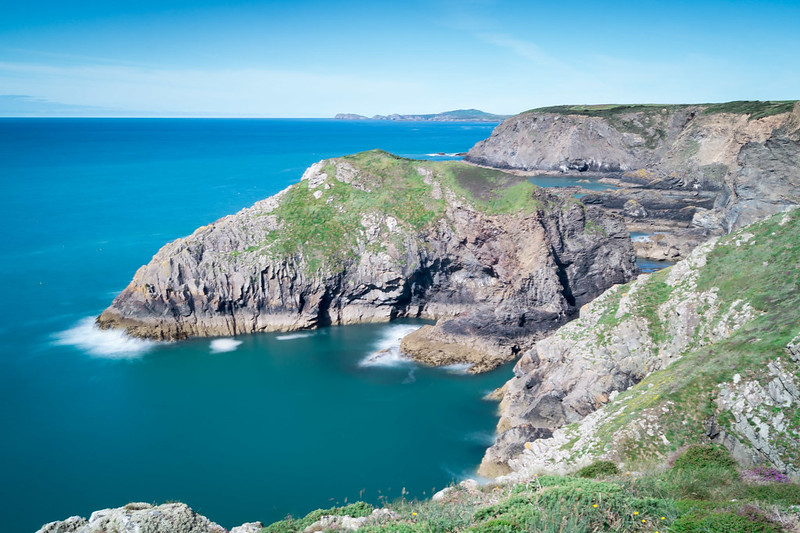
The Lorian Swamp, also known as the Lorian Marsh, is a significant wetland area located in Kenya, East Africa. It is a vast expanse of marshes and swamps that are fed by numerous rivers and streams. One of the major rivers that flows into the Lorian Swamp is the Mara River, which holds great importance in the ecosystem of the region.
The Mara River originates from the Mau Escarpment in Kenya and meanders through the iconic Maasai Mara National Reserve before finally reaching the Lorian Swamp. The river serves as a lifeline for the diverse wildlife in the area and is renowned for the annual wildebeest migration, one of the world's most spectacular natural events. During this migration, thousands of wildebeest and other herbivores cross the Mara River in search of fresh grazing lands. The Mara River plays a crucial role in the ecosystem of the Lorian Swamp. It not only provides a source of water but also supports a rich variety of plant and animal life. The presence of the river ensures the availability of water throughout the year, sustaining the wetland habitat and its unique flora and fauna. The lush vegetation in the Lorian Swamp serves as a breeding ground for various bird species and provides a sanctuary for numerous amphibians, reptiles, and small mammals. Furthermore, the Lorian Swamp is home to a wide range of aquatic species, including fish, frogs, and water insects. These organisms rely on the swamp's nutrient-rich waters for their survival. The interconnectedness between the Mara River and the Lorian Swamp creates a delicate balance in the ecosystem, supporting the intricate web of life that thrives in this wetland habitat. In conclusion, the Lorian Swamp is a vital wetland area in Kenya, sustained by the Mara River. This vast marshland supports a diverse array of plant and animal life, including migratory species such as wildebeest. The river's flow provides a continuous water supply, creating a thriving ecosystem in the Lorian Swamp. Preserving and conserving this unique wetland habitat is crucial for the long-term sustainability of the region's biodiversity.
0 Comments
The longest river in Kenya is the Tana River. It stretches approximately 1,014 kilometers (630 miles) in length, making it the longest river in the country. The Tana River begins its journey in the Aberdare Range in central Kenya and flows eastwards towards the Indian Ocean. It passes through various landscapes, including forests, savannahs, and arid areas, before reaching its delta at the Indian Ocean near the town of Malindi.
The Tana River is of great importance to Kenya as it provides water for irrigation, hydroelectric power generation, and supports various ecosystems along its course. It is also a vital water source for agriculture, wildlife, and human settlements in the region. The river is home to a diverse range of flora and fauna, including several species of fish, crocodiles, and hippos. The Tana River has played a significant role in the history and development of Kenya, providing water for irrigation and power generation, as well as being a transportation route for goods and people. It is also a popular destination for activities such as white-water rafting and birdwatching. In conclusion, the Tana River is the longest river in Kenya, stretching over 1,014 kilometers. It is an important water source and supports various ecosystems and human activities along its course. The source of the Tana River is located in the Aberdare Range in central Kenya. The Aberdare Range is a mountain range that stretches across the central part of the country. It is a part of the Eastern Branch of the East African Rift System. The Tana River originates from the slopes of Mount Satima, which is the highest peak in the Aberdare Range, standing at an elevation of 4,001 meters (13,120 feet) above sea level.
From its source, the Tana River flows eastwards, meandering through the picturesque landscapes of the Aberdare National Park. It then continues its journey, passing through various regions and eventually forming the border between Tana River County and Tharaka Nithi County. As it progresses, the Tana River provides water to irrigation schemes, hydroelectric power generation, and sustains the diverse ecosystems along its course. The Tana River is a lifeline for many communities in Kenya, supporting agriculture, wildlife, and human settlements. It eventually reaches the Indian Ocean near the town of Malindi, forming a delta and providing important habitats for numerous aquatic species. In conclusion, the Aberdare Range in central Kenya is the source of the Tana River. The river plays a vital role in the livelihoods of people and the ecosystems it traverses, flowing from its origin in the Aberdare Range to its delta at the Indian Ocean. River capture, also known as stream piracy or stream capture, refers to the natural diversion of the headwaters of one river into the channel of another river with greater erosional activity. It is an important geomorphic process that can reshape landscapes and alter river systems. To understand the conditions necessary for river capture to occur, we can refer to the information provided in the documents. State three conditions necessary for river capture to take place. (3mks)
In conclusion, river capture is a natural process that occurs when the headwaters of one river are diverted into the channel of another river with greater erosional activity. Three necessary conditions for river capture to take place include a difference in river levels, adjacent valleys and watersheds, and the presence of a wider valley and more active headward erosion in the pirate river. Understanding these conditions helps us comprehend the complex dynamics of river systems and their evolution over time.
River Capture: Features, Conditions, and Examples of this Natural PhenomenonDefine the term river capture (2mks) The diversion of the headwaters of a less powerful river into a more powerful river in an adjacent valley. River capture, also known as stream piracy or stream capture, refers to the natural phenomenon where the headwaters of a less powerful river are diverted into the channel of a more powerful river in an adjacent valley.
This process occurs when the tributaries of the more powerful river erode their source through headward erosion and capture the headwaters of the adjoining system. The captured river, also known as the misfit or underfit stream, loses its original headwaters and its flow is redirected into the channel of the capturing river. During river capture, several features and conditions can be observed:
In western Kenya, the Sondu River was captured by the Miriu River from the Asaw River, leaving a wind gap at the present Sondu market. River capture can also be observed in Europe, such as the capture of the upper Doubs from the Rhine and the capture of the former upper Meuse by the Moselle near Toul. In summary, river capture is the process by which the headwaters of a less powerful river are diverted into a more powerful river in an adjacent valley. It is characterized by features such as elbows of capture, drygaps, and river rejuvenation. Several conditions must be met for river capture to occur, including adjacent valleys, differential erosion, and active headward erosion. Significance of Rivers to human Activities
Ways in which a river transports its load
Define the term river. (2mks)
Is a natural flowing stream of water in a channel from upland area towards the low land. Differentiate between a catchment area and a river divide. (2mks)
A catchment area is an area where a river draws its water while a river divide is a boundary/ridge that separates drainage basins. State FIVE factors which influence the ability of a river to deposit materials. (5mks)
Describe FOUR ways by which a river transports its load. (8mks)
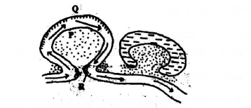
KCSE Geography Paper 1 2001 Section A Question 5. (a) What are natural levees?
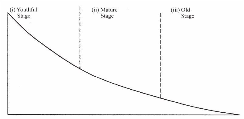
(b) The diagrams below shows a section of a river. Use it to answer the questions that Follow.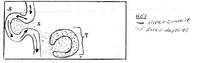 (i) At what stage development is this section of the river?
The map below shows the physical regions of Kenya. Use it to answer the questions that follow.28/2/2021 KCSE Geography Paper 1 2002 Section B Question 7. The map below shows the physical regions of Kenya. Use it to answer the questions that follow.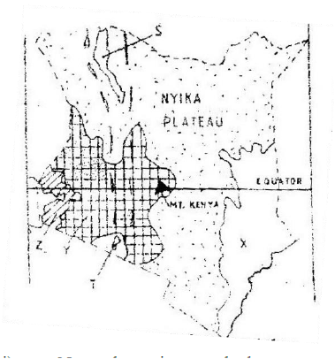 a) i) Name the regions marked. X, Y and Z.
ii) Give the major economic importance of each of the lakes marked S and T.
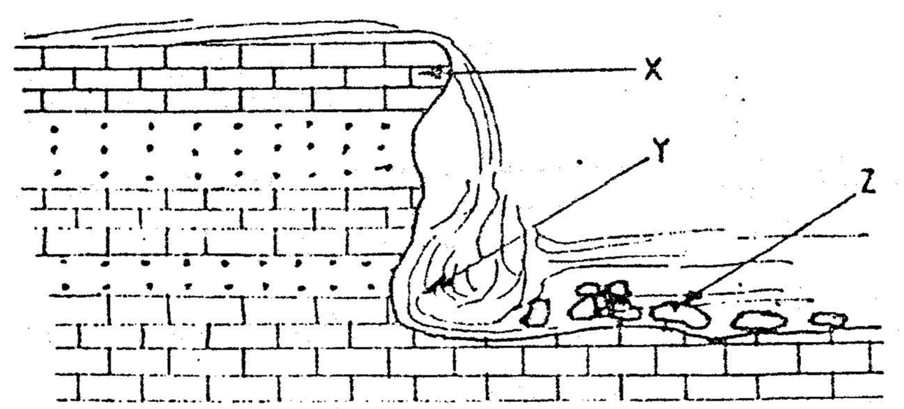
KCSE Geography Paper 1 2002 Section A Question 2. Use the diagram below to answer question (a) 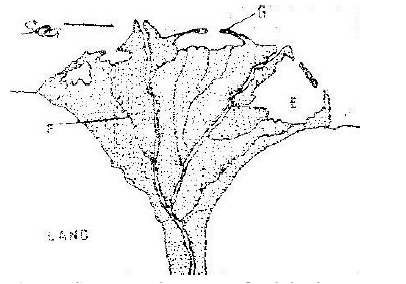 a) i) What type of a delta is represented by the diagram?
ii) Name the features marked E,F, and G.
b) State two conditions necessary for the formation of a delta.
KCSE Geography Paper 1 2003 Section A Question 1. a) State TWO factors that influence the rate of erosion by the river in its upper course.
b) (i) Define river rejuvenation
Name two features that result from river rejuvenation
 KCSE Geography Paper 1 2004 Section B Question 8. a) State four factors that determine the amount of surface run off .
b) Describe three ways in which a river transports its load
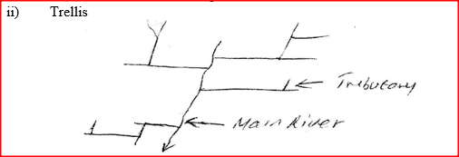
c) Using a diagrams, describe the following drainage patterns |

Archives
March 2024
Categories
All
|


 RSS Feed