KCSE Geography Paper 2 2000 Section A Question 2 with Answers.(a) State two human activities that may be lead to soil erosion
0 Comments
KCSE Geography Paper 2 2003 Section B Question 9. Use the map of North America (in question paper) to answer question (a) 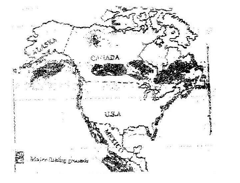 a)i) Name two methods of fishing used in the shaded areas,
ii) Name two types of fish caught along the west coast of Canada
KCSE Geography Paper 2 2003 Section B Question 8. a) Name three agricultural non food manufacturing industries in Kenya.
b)i) Draw outline map of Kenya (map should have a frame / outline correct).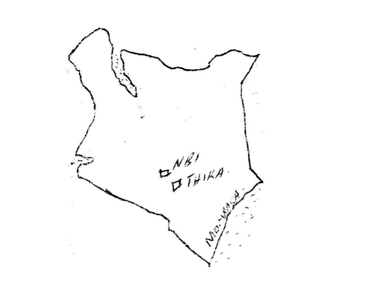 ii) On the outline map, mark and name two towns where motor vehicles are assembled.
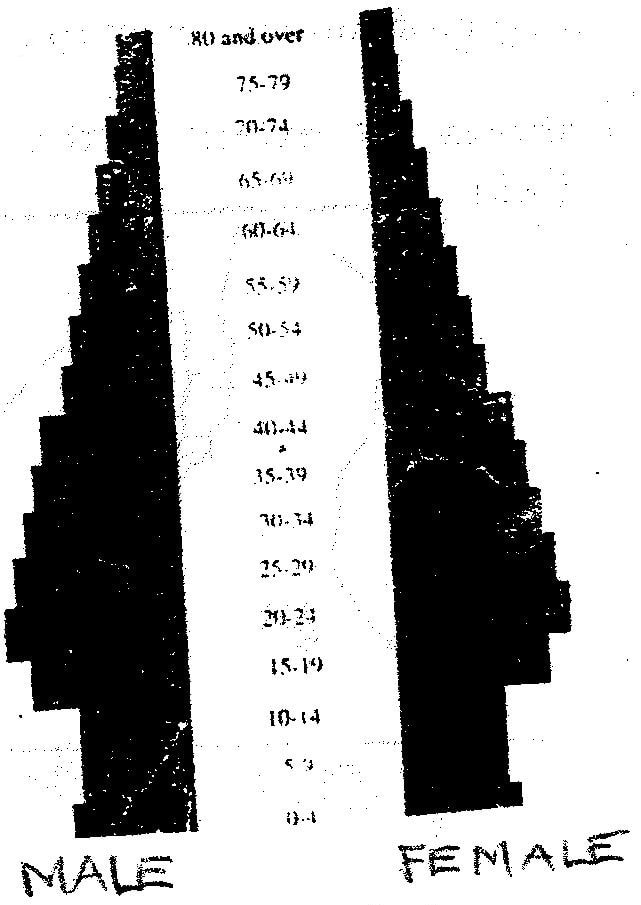
KCSE Geography Paper 2 2003 Section B Question 7. a) i) Give two primary sources of population on data.
ii) What information can be derived from a population pyramid?
b) Describe three ways in which the population of Kenya differs from that of Sweden.
 KCSE Geography Paper 2 2003 Section A Question 5. a) State three reasons why National parks have been established in Kenya.
b) A part from marine parks, give two other tourist attractions found at the coast of Kenya.
 KCSE Geography Paper 2 2003 Section A Question 4. a) Why is it necessary to conserve water?
b) How does terracing help in water conservation?
 KCSE Geography Paper 2 2003 Section A Question 2. a) A part from draining swamps, state two other methods used in reclaiming land in Kenya.
b) State three benefits that resulted from reclamation of the Yata swamp
 KCSE Geography Paper 2 2003 Section A Question 1. a) What is urbanization?
b) Give two differences in the function of New York and Nairobi cities. New York Nairobi
 KCSE Geography Paper 1 2000 Section b Question 6 with Answers.Study the map of Mathioya 1: 50,000 provided and answer the following questions(a) (i) What is the bearing of the cattle dip at grid reference 716386 form the coffee factory at grid reference 740377?
(i) - 290 degrees
(ii) Give the approximate height of Kigoini dam
(ii) - 1000m above sea level
(iii) Measure the length of the district boundary in the Aberdare forest from Western margin of the map to the eastern edge of the forest (Give your answer in kilometers)
(iii) - 12.3 km or 12.2 km or 12.4 km
(b) Describe the drainage of the area covered by the map
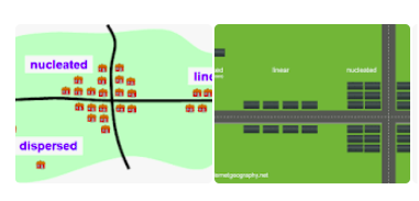
KCSE Geography Paper 2 2004 Section B Question 9. a) i) Name two types of rural settlement patterns.
ii) A part from urban-rural migration. Name two other types of migration.
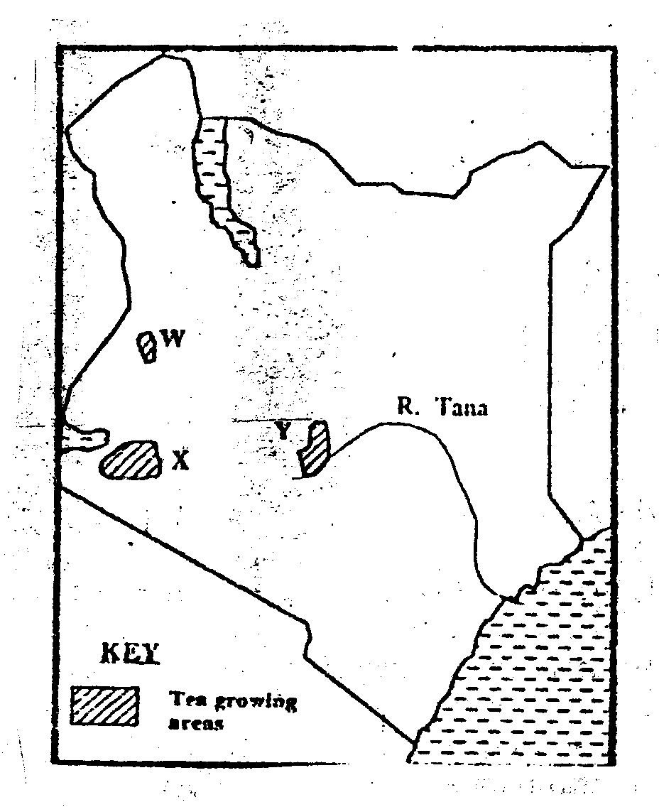
 KCSE Geography Paper 2 2004 Section B Question 8. a) i) Name three physical regions through which River Tana passes .
ii) Explain three effects of land pollution can be controlled
b) State four ways through which land pollution can be controlled
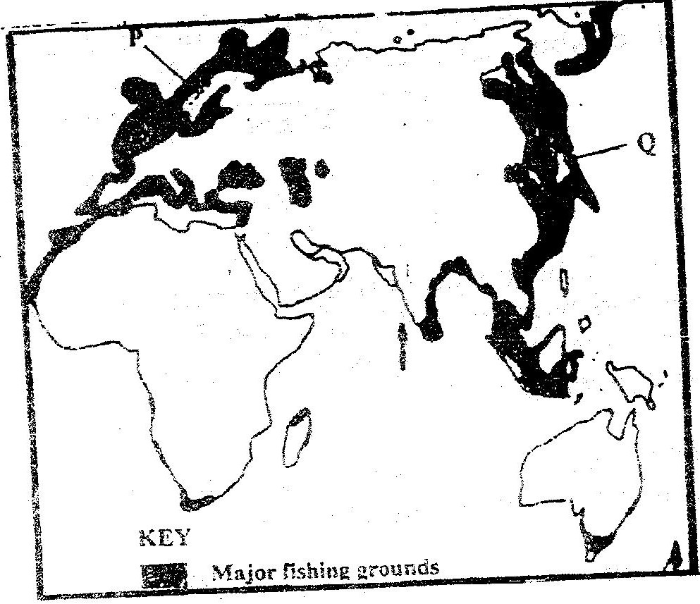
 KCSE Geography Paper 2 2004 Section B Question 7. Use the map of East Africa below to answer questions (s). 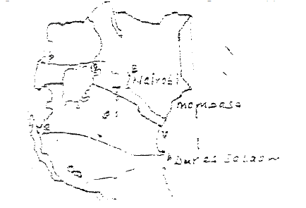 a) (i) Name the railway terminuses marked P, Q R
(ii) In each case give the main commodity transported by the railway lines marked S and T.
KCSE Geography Paper 2 2004 Section A Question 4. a) Differentiate between manufacturing and tertiary industries
b) State three factors that led to the growth of iron and steel industry in the Ruhr region of Germany
 A part from historical sites name two tourist attractions along the coastal strip of Kenya.24/2/2021 KCSE Geography Paper 2 2004 Section A Question 3. a) A part from historical sites name two tourist attractions along the coastal strip of Kenya.
b) Give three reasons why it is necessary to preserve historical sites
 KCSE Geography Paper 2 2005 Section B Question 9. a) i) Define international trade
ii) Name three major imports from Europe to Kenya
 b) State four factors that influence external trade in Kenya
KCSE Geography Paper 2 2005 Section B Question 6. The table below shows the approximation of four districts in central province in 1999. Use it to answer question (a)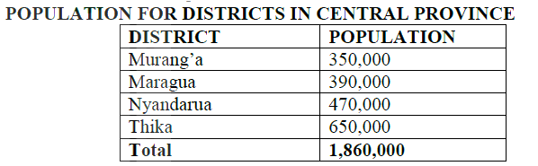 (a) (i) Suggest two possible reasons why the population of Thika is higher than that of Murang’a
(ii) Using a radius of 5 cm, draw a pie chart to represent the data above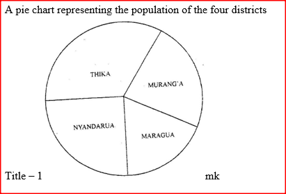 KCSE Geography Paper 2 2005 Section A Question 4. State four ways in which drought affects the agricultural sector in Kenya
 KCSE Geography Paper 2 2005 Section A Question 3. The Sketch map below shows Hydro- Electric Power (H.E.P) stations along the River Tana. Use it to answer questions (a) (i) and (ii) 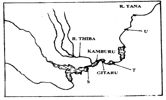 Name |

Archives
March 2024
Categories
All
|

 RSS Feed