|
KCSE Geography Paper 1 2005 Section A Question 4. (a) Name a place in Kenya where tarns are found
(b) Describe how a tarn is formed
0 Comments
KCSE Geography Paper 1 2005 Section A Question 3. (a) State two characteristics of sedimentary rocks
(b) Give two examples of chemically formed sedimentary rocks
 KCSE Geography Paper 1 2005 Section A Question 2. (a) The diagram below shows the hydrological cycle. 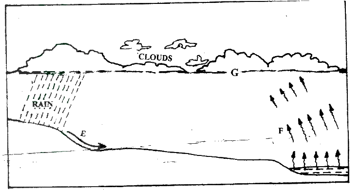 Name the stages marked E, F, and G
(b) Differentiate between watershed and a catchments area
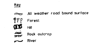
KCSE Geography Paper 1 2005 Section A Question 1. (a) Name two theories of the origin of the earth
(b) Name four layers of the earth’s atmosphere
 KCSE Geography Paper 1 2006 Section B Question 10. a) (i) What is soil catena?
(ii) Draw a labeled diagram to show a well developed soil profile.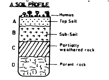 (iii) State three characteristics of the soils found in the arid regions of Kenya.
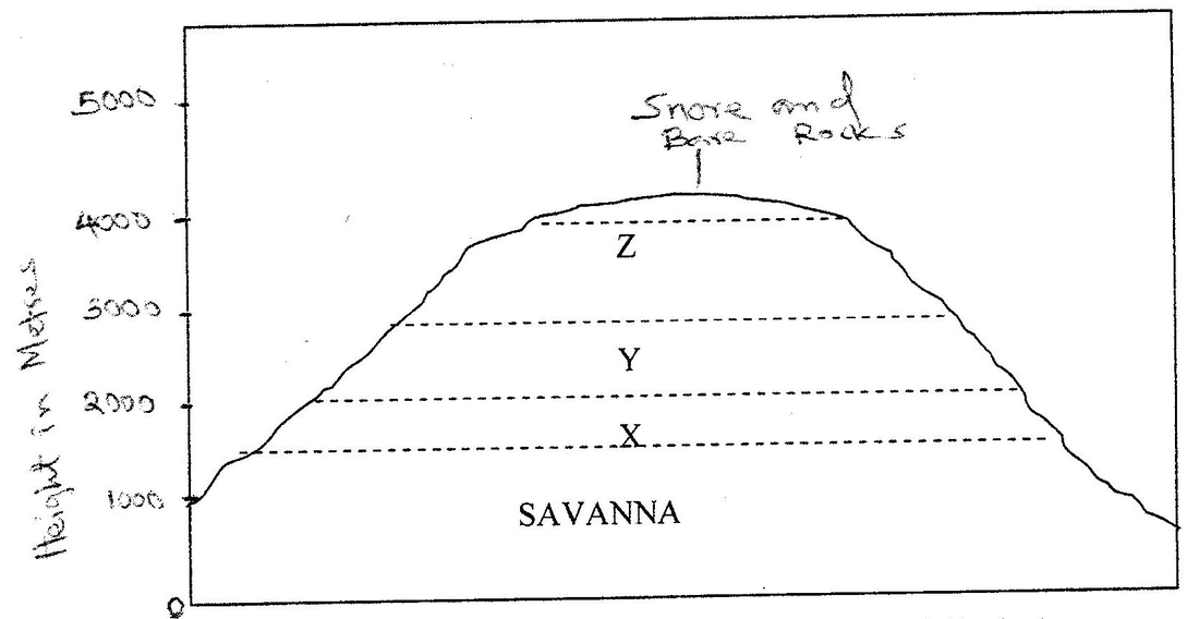
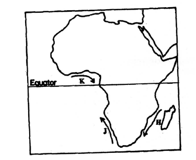
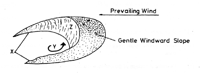
KCSE Geography Paper 1 2006 Section B Question 9. The diagram below represents zones of natural vegetation on a mountain in Africa. Use it to answer question (a) (i) and (ii)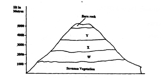 a) (i) Name the vegetation zones marked W, X and Y.
(ii) Describe the characteristics of the savanna vegetation.
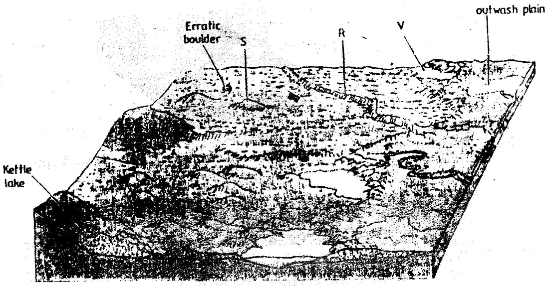
KCSE Geography Paper 1 2006 Section B Question 8. (a) (i) What is an ice sheet?
(ii) Give two reasons why there are no ice sheets in Kenya
(iii) Explain three factors that influence the movement of the ice from the place where it has accumulated
KCSE Geography Paper 1 2006 Section B Question 7. The diagram below shows river Mandera. Use it to answer question ( a)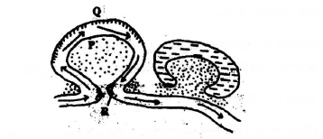 (a) (i) Name the process that take place at each of the points marked P and Q.
(ii) Name the feature formed at the point marked R
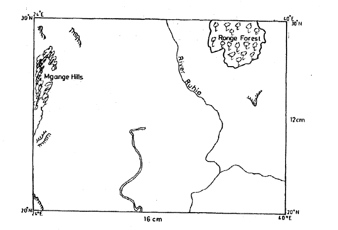
Study the map of Nyahururu, 1: 50,000 (sheet 105/4) provided and answer the following questions19/2/2021 KCSE Geography Paper 1 2006 Section B Question 6. (a) (i) Give the six figure grid of the junction where the road to Ndaragwa (D 388) meets with the road to Nyeri & Nanyuki (B5)
(ii) Calculate the bearing of point X from point Y
(iii) Name three physical features found along the line XY
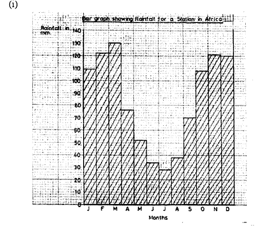
KCSE Geography Paper 1 2006 Section A Question 5. The table below represents rainfall and temperature figures for a town in Africa. Use it to answer the questions that follow  (a) (i) calculate the annual range of temperature for the town
(b) State two characteristics of the climate experienced in the town
KCSE Geography Paper 1 2006 Section A Question 4. (a) Name two scales used to measure the intensity of an earthquake
(b) Give three causes of earthquakes
 KCSE Geography Paper 1 2006 Section A Question 3. The diagram below shows the composition of the solar system  (a) Name the planets marked F and G
(b) State three effects of the rotation of the earth on its axis
KCSE Geography Paper 1 2006 Section A Question 2. Give two processes involved in each of the following types of weathering |

Archives
March 2024
Categories
All
|


 RSS Feed
|
Primary Resources
College Resources
|
Secondary Resources
|
Contact Us
Manyam Franchise
P.O Box 1189 - 40200 Kisii Tel: 0728 450 424 Tel: 0738 619 279 E-mail - sales@manyamfranchise.com |